
Fatih Sultan Mehmet Bridge
41.0911° N · 29.0614° E · Bridge
Photo: Glabb · CC BY-SA 3.0 · Wikimedia Commons
Fatih Sultan Mehmet Bridge is a bridge in İstanbul, Turkey. Opened in 1988 as Istanbul's second Bosphorus bridge. The free Lokali audio guide runs 7 minutes.
✓ Published October 2026 · how we write these guides
Visitor facts
| Lokali audio guide | 7 min · free |
|---|---|
| Type | Bridge |
| Location | Istanbul, Türkiye |
| Coordinates | 41.0911, 29.0614 |
| Languages | 50+, in the Lokali app |
The story
Listen first. Beneath the steady hum of traffic overhead, there is another sound: water. The Bosphorus moves fast here, a cold blue current running from the Black Sea toward the Sea of Marmara. Gulls ride the wind along the shore. High above, two pale towers hold up a long, shallow curve of steel. Cars cross it in a constant stream, small as beads on a thread. You are standing beside one of the places where two continents nearly touch.
This is the Fatih Sultan Mehmet Bridge, the second bridge built across the Bosphorus in Istanbul. It opened in 1988, fifteen years after the first bridge further south. On one side lies Europe, on the other lies Asia. The strait between them is narrow here — one of the narrowest points along its whole length. That simple fact of geography explains why this stretch of water has drawn builders, armies, and engineers for thousands of years.
The bridge is a suspension bridge. Two main cables run over the tops of the towers and anchor deep into the land on each shore. Vertical hangers drop from those cables and carry the road deck. The main span between the towers is about 1,090 metres long. There is no pier standing in the water. That was important. The Bosphorus is a busy shipping lane, and tankers, cargo ships, and ferries pass beneath without anything in their way.
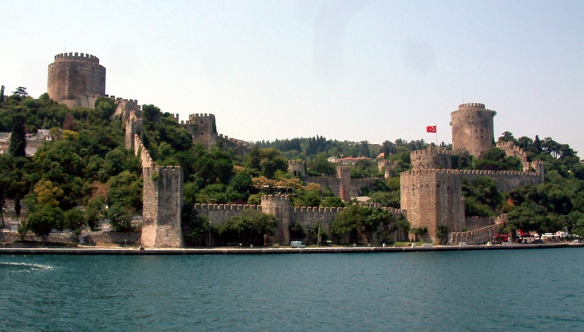
Now look along the European shore, just south of the bridge. You will see grey stone walls climbing the hillside, with round towers rising among the trees. That is Rumeli Hisarı, the Rumelian Fortress. Sultan Mehmed the Second built it in 1452, in a remarkably short time. A year later, in 1453, his army took Constantinople, the capital of the Byzantine Empire. History remembers him as Fatih — the Conqueror. This bridge carries his name.
The placement is not an accident. The fortress was built to control this narrow passage. Across the water, on the Asian side, stands an older and smaller fortress, Anadolu Hisarı, built by an earlier Ottoman sultan. Between the two strongholds, the Ottomans could watch every ship that moved along the strait. Today a modern bridge spans the same gap. Five centuries separate the stone walls and the steel cables, but both answer the same question: how to master this crossing.
Here is something many visitors do not know. The idea of a bridge at this spot is very, very old. The ancient Greek historian Herodotus wrote that the Persian king Darius the First crossed the Bosphorus on a bridge of boats, in the late sixth century before the common era. He was marching an army into Europe. Tradition places that crossing close to where you are now. We cannot point to the exact spot. But the story shows how long people have looked at this narrow water and imagined a way over it.
Back to the modern bridge. By the 1980s, Istanbul was growing fast. The first Bosphorus bridge could no longer handle the traffic between the two halves of the city. A second crossing was planned further north, as part of a ring motorway around Istanbul. The construction was carried out by an international group of companies, with Japanese firms playing a leading role alongside Turkish and Italian partners. The steel deck was assembled in sections and lifted into place from below.
Take a moment to look at the deck itself. From the shore, it seems very thin — almost like a ribbon. That slim profile is typical of bridges designed in this period. The deck is shaped a little like an aircraft wing in cross-section. This helps the wind flow smoothly around it instead of pushing against it. On a strait where strong winds funnel between hills, that design choice matters a great deal.
One practical surprise: you cannot walk across this bridge. It carries motorway traffic only, and pedestrians are not allowed on the deck. So the best way to experience it is from below or from the side. Many people see it from the deck of a Bosphorus ferry or cruise boat. As the boat slides under the span, you can look straight up at the underside of the road. The scale becomes clear only from there.
The neighbourhoods on each end carry their own character. On the European side, the land rises toward Hisarüstü and the hills around Boğaziçi University. Down at the water, Rumeli Hisarı has a string of small cafés and fish restaurants along the shore road. On the Asian side, the bridge lands near Kavacık. Below it, around Anadolu Hisarı, a small stream called the Göksu meets the Bosphorus, and old wooden houses still stand near the water.
Watch the water for a while. Large ships move slowly through the strait, often guided by local pilots, because the currents and bends here are difficult. Small fishing boats hold their position near the shore. Ferries cut diagonal lines from one continent to the other. On some days you may see dolphins break the surface — they live in these waters, though sightings are never guaranteed. The bridge stands above all this movement, still and steady.
As evening comes, the light changes everything. The sun sets behind the European hills, and the towers turn dark against an orange sky. Then the bridge lighting comes on, and the cables trace a glowing line across the strait. The reflection breaks into pieces on the moving water. Seen from the fortress walls or from a waterfront terrace, the bridge looks less like a motorway and more like a drawing in light.
So take one last look. To your side stands a fortress built by a young sultan preparing to take a city. Above you hangs a steel road that carries his name and thousands of travellers every hour. Below you runs the same cold current that Persian soldiers, Byzantine sailors, and Ottoman guards all knew. As you walk away, listen again for the water beneath the traffic. It was here long before the bridge — and it will keep moving long after.
Key facts
What to look for
Practical tips
Common questions
Is there a free audio guide to Fatih Sultan Mehmet Bridge?
Yes — the Lokali app narrates Fatih Sultan Mehmet Bridge free of charge in 50+ languages. The guide runs about 7 minutes, covers the history, what to look for on site and practical tips, and works offline once downloaded.
Where is Fatih Sultan Mehmet Bridge?
Fatih Sultan Mehmet Bridge is in Istanbul, Türkiye, at 41.0911, 29.0614. Tap the map link on this page for directions from where you are.
What is Fatih Sultan Mehmet Bridge known for?
Opened in 1988 as Istanbul's second Bosphorus bridge. Main span between the towers is about 1,090 metres.
What should you look for at Fatih Sultan Mehmet Bridge?
The slim, wing-shaped steel deck seen from below. Rumeli Hisarı's round stone towers just south of the bridge. No piers stand in the water between the towers.
What should you know before visiting Fatih Sultan Mehmet Bridge?
Take a Bosphorus ferry to pass directly beneath the span. Walk the Rumeli Hisarı shore road for side views.
When is the best time to visit Fatih Sultan Mehmet Bridge?
Stay until dusk to see the bridge lighting come on.
On the map
Opens directions to Fatih Sultan Mehmet Bridge from your location.
More to see in Istanbul


Hear Fatih Sultan Mehmet Bridge in your language
The full story, narrated, in 50+ languages. Download it before you go and it plays offline, at your own pace, with no ticket and no tour group.