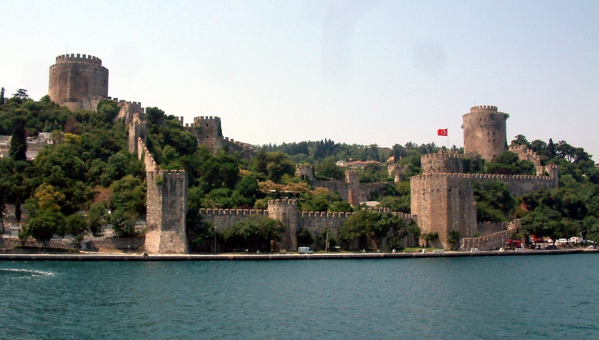
Photo: Wikimedia Commons contributor · CC BY-SA 3.0 · Wikimedia Commons
Rumelihisarı is an Ottoman castle in Istanbul. Built by Sultan Mehmed the Second in 1452. The free Lokali audio guide runs 6 minutes.
✓ Published October 2026 · how we write these guides
Visitor facts
| Lokali audio guide | 6 min · free |
|---|---|
| Type | Museum |
| Location | Istanbul, Türkiye |
| Coordinates | 41.0847, 29.0561 |
| Languages | 50+, in the Lokali app |
The story
Listen first. Water slaps against the stone quay below you, and a ferry horn rolls across the strait from the Asian shore. The air smells of salt and diesel, and of tea from the cafés along the road. Above you, grey walls climb the hillside in steep steps, broken by three heavy towers. This is Rumelihisarı, the Fortress of Rumelia, and it was built for one purpose only: to close this water.
Look out across the Bosphorus. The strait is narrow here, one of its tightest points between the Black Sea and the Sea of Marmara. On the far bank, almost directly opposite, sits a smaller, older castle called Anadoluhisarı. An earlier Ottoman sultan, Bayezid the First, built that one in the late fourteenth century. Together, the two fortresses face each other like a pair of jaws, and every ship heading south must pass between them.
The man behind this fortress was Sultan Mehmed the Second. He was barely twenty years old when he ordered the work in 1452. At that moment, Constantinople was still the capital of the Byzantine Empire, the last remnant of the old Eastern Roman state. Mehmed wanted that city. To take it, he first needed to stop food and soldiers arriving by sea from the Black Sea ports. This fortress was the first move in that plan.
Here is the first surprise. The whole structure went up in a matter of months, not years. Most accounts say the builders finished in roughly four months during the spring and summer of 1452. Thousands of workers, masons and labourers moved stone up this slope at a speed that alarmed Constantinople. The Byzantine emperor sent envoys to protest. Mehmed did not stop. The walls kept rising.
The Ottomans gave the fortress a blunt nickname: Boğazkesen. It can be translated as the cutter of the strait, but the Turkish word for strait also means throat. So the name carries a double meaning. This castle was the blade at the city's throat. Soon after completion, cannons were placed near the water. Ships that passed were expected to stop and pay a toll.
The warning was real. Within months, a Venetian merchant ship tried to sail past without stopping. The guns opened fire and sank it. Historical accounts record that the captain was captured and executed as an example to others. After that, the message was clear to every sailor on the Bosphorus. In the spring of 1453, Mehmed laid siege to Constantinople, and the city fell to him that May.
Now turn your attention to the towers. There are three large ones, and each is linked to one of Mehmed's senior commanders. The tradition is that each man was responsible for building his own section, and that they competed to finish first. The towers carry the names of Saruca Pasha, Halil Pasha and Zağanos Pasha. The tallest stands near the shore, and its walls are remarkably thick.
If you walk the paths inside, notice how the walls do not form a neat square or circle. They follow the shape of the hill, bending around rock and dropping toward the sea. There is a popular legend about this layout. Some locals say the outline was designed to spell Mehmed's name in Arabic letters when seen from above. It is a lovely story, but historians generally treat it as folklore rather than fact.
After 1453, the fortress lost its main job. Constantinople was now Ottoman, and there was no enemy capital to blockade. The castle served for a time as a customs post and later as a prison. Over the following centuries, a small neighbourhood grew inside the walls, with wooden houses packed between the towers. People lived their ordinary lives inside a military monument. Here is the second surprise: the fortress was a village for generations.
In the twentieth century, those houses were cleared, and the fortress was restored. It opened as a museum around the late 1950s. In the decades that followed, the open slopes inside became a stage for summer concerts. Imagine music rising off these old stones on a warm evening, with the lights of ships sliding past below. Restoration work has continued in recent years, so some areas may look newer than others.
As you climb, look for the remains of a small mosque inside the walls. Only traces survive today, including the stump of its minaret. Look also at the stonework itself. You will see rough grey blocks mixed with pieces of brick and reused stone. The builders worked fast and used what they could find. Near the entrance and along the paths, old cannonballs and gun barrels are laid out on display.
From the upper walls, the view opens in both directions. To the north, a long suspension bridge crosses the strait — the Fatih Sultan Mehmet Bridge, named after the same sultan who built this fortress. Fatih means the Conqueror. So the man who once closed this water now lends his name to the road that joins its two shores. Behind you, the green slopes rise toward the campus of Boğaziçi University.
When you leave, walk slowly along the waterfront road. Notice the fishermen on the quay, the waiters carrying trays of tea, the families waiting for breakfast tables in the cafés. Look back once at the towers above the rooftops. Then look across to the smaller castle on the Asian shore. For a few seconds, you are standing exactly where a young sultan stood and measured the distance to the other side.
Key facts
What to look for
Practical tips
Common questions
Is there a free audio guide to Rumelihisarı?
Yes — the Lokali app narrates Rumelihisarı free of charge in 50+ languages. The guide runs about 6 minutes, covers the history, what to look for on site and practical tips, and works offline once downloaded.
Where is Rumelihisarı?
Rumelihisarı is in Istanbul, Türkiye, at 41.0847, 29.0561. Tap the map link on this page for directions from where you are.
What is Rumelihisarı known for?
Built by Sultan Mehmed the Second in 1452. Construction took only about four months.
What should you look for at Rumelihisarı?
Three great towers named after Mehmed's commanders. Anadoluhisarı castle directly across the water. Old cannonballs and gun barrels displayed inside.
What should you know before visiting Rumelihisarı?
Wear sturdy shoes for the steep, uneven stone paths. Climb the upper walls for the widest Bosphorus views.
When is the best time to visit Rumelihisarı?
Visit late afternoon when light falls on the Asian shore.
On the map
Opens directions to Rumelihisarı from your location.
More to see in Istanbul


Hear Rumelihisarı in your language
The full story, narrated, in 50+ languages. Download it before you go and it plays offline, at your own pace, with no ticket and no tour group.