Tsingy de Bemaraha National Park
18.6667° S · 44.7833° E · National Park
Tsingy de Bemaraha National Park is a national park in Madagascar. Tsingy means where one cannot walk barefoot in Malagasy. UNESCO World Heritage Site since 1990. Most visitors spend 4-6 hours here. The free Lokali audio guide runs 6 minutes.
✓ Verified October 2026 · how we write these guides
Visitor facts
| Time needed | 4-6 hours |
|---|---|
| Lokali audio guide | 6 min · free |
| Type | National Park |
| Best for | Photography |
| Location | Madagascar, Madagascar |
| Coordinates | -18.6667, 44.7833 |
| Languages | 45, in the Lokali app |
The story
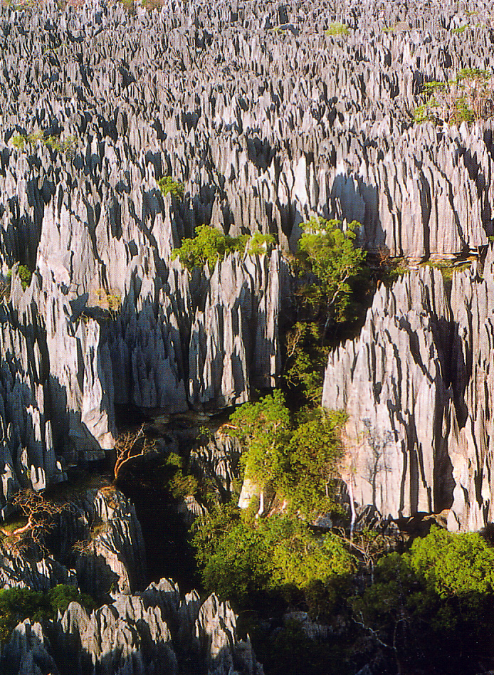
The ground beneath your feet is not quite rock, not quite blade — it is limestone carved into a forest of razor-sharp pinnacles, each one tilted at a different angle, some as tall as a five-story building. The Malagasy word tsingy means "where one cannot walk barefoot," and standing here at the edge of this stone labyrinth, you understand why. The air smells faintly mineral, almost chalky, and when the wind moves through the formations it produces a low, hollow whistle.
This park covers nearly one hundred and fifty thousand hectares in western Madagascar, split into two main zones — the smaller Petits Tsingy and the vast, forbidding Grands Tsingy. The stone forest you see formed over millions of years as rainwater, slightly acidic from dissolved carbon dioxide, ate away at an ancient seabed of limestone. What remains are these knife-edge ridges and deep canyons, some of them fifty metres from rim to floor. The rock is pale grey in morning light, almost white at midday, and takes on a warm amber glow near sunset.
UNESCO listed Tsingy de Bemaraha as a World Heritage Site in 1990, recognizing both its geological rarity and the species that live nowhere else on Earth. Eleven species of lemur move through the canopy above the tsingy — including the elusive Decken's sifaka, a white lemur with a black face that leaps horizontally between the pinnacles. More than one hundred bird species nest in the crevices, and the park shelters fossas, Madagascar's largest carnivore, a cat-like predator that hunts along the stone ridges at dusk.
The formations themselves are not uniform. In some sections the pinnacles stand close together, almost touching, creating narrow slots you can walk through if you turn your shoulders. In others they spread into wider clearings where pockets of soil have collected and baobabs have taken root, their swollen trunks rising improbably from the stone. The contrast is striking — soft green leaves against hard grey edges, life finding purchase in the thinnest layer of earth.
Visitors navigate the Grands Tsingy on a network of suspended bridges and steel ladders bolted into the rock. The bridges sway slightly as you cross, and through the gaps in the planks you can see straight down into the canyons below, where ferns and orchids cling to the shaded walls. The route is physically demanding — expect to climb, duck, and occasionally squeeze through gaps barely wider than your body. Gloves are essential; even a light brush against the stone can draw blood.
Beneath the surface lies another world entirely. The same water that carved the pinnacles also hollowed out a vast cave system, much of it still unexplored. The Manambolo River runs through the park, and in places it disappears underground, carving tunnels and chambers through the limestone. A few caves are accessible to visitors with guides, and inside the temperature drops noticeably. Stalactites hang from the ceilings, and the walls are slick with moisture. Bats roost in the high chambers, and their droppings support entire ecosystems of insects and fungi.
The park sits in one of Madagascar's driest regions, and the surrounding landscape is deciduous forest that sheds its leaves during the long dry season from April to November. During the rains, from December to March, the forest greens rapidly and the rivers swell. The tsingy formations channel rainwater into deep underground aquifers, and this hidden water sustains the forest through the dry months. Local communities have lived alongside the tsingy for generations, and some areas within the park are considered sacred — burial sites are tucked into caves and crevices, and certain formations are off-limits even to researchers.
The remoteness of Tsingy de Bemaraha has protected it but also makes access challenging. The park lies roughly three hundred kilometres north of Morondava, and the journey involves hours on rough dirt roads that become impassable during heavy rains. Most visitors fly into Morondava and arrange multi-day trips with local guides. The isolation means the park sees far fewer tourists than Madagascar's eastern rainforests, and on some trails you may walk for an hour without encountering another person.
The light changes constantly as you move through the formations. In the morning, low sun casts long shadows across the ridges, emphasizing every edge and crevice. By midday the stone glows almost white, and the heat radiates back from the rock, making the air shimmer. Late afternoon is the most forgiving time to explore — the temperature drops slightly, and the amber light softens the harshness of the landscape. Birds become more active, and if you are quiet and patient near the forest edge, you may spot a lemur moving through the canopy.
Standing at one of the high viewpoints, looking out over thousands of hectares of stone pinnacles stretching to the horizon, the scale becomes almost abstract. It is difficult to process that every ridge, every canyon, every blade of rock was shaped by water, grain by grain, over unimaginable spans of time. The tsingy does not invite casual exploration — it demands respect, attention, and a willingness to move slowly. But for those who take the time, it offers something rare: a landscape unlike anything else on the planet, a place where geology and biology have conspired to create beauty that is both brutal and strangely delicate.
Key facts
What to look for
Practical tips
Common questions
How long do you need at Tsingy de Bemaraha National Park?
Plan 4-6 hours. That is the time most visitors spend at Tsingy de Bemaraha National Park. The free Lokali audio guide runs 6 minutes and is made to listen to while you walk.
Is there a free audio guide to Tsingy de Bemaraha National Park?
Yes — the Lokali app narrates Tsingy de Bemaraha National Park free of charge in 50+ languages. No ticket, tour group or subscription, and it works offline once downloaded.
Where is Tsingy de Bemaraha National Park?
Tsingy de Bemaraha National Park is in Madagascar, Madagascar, at -18.6667, 44.7833. Tap the map link on this page for directions.
What should you know before visiting Tsingy de Bemaraha National Park?
Bring sturdy gloves to protect hands from sharp limestone
What is Tsingy de Bemaraha National Park known for?
Tsingy means where one cannot walk barefoot in Malagasy
What is the best time to visit Tsingy de Bemaraha National Park?
Visit during dry season April to November for best access
On the map
Opens directions to Tsingy de Bemaraha National Park from your location.
More to see in Madagascar
Hear Tsingy de Bemaraha National Park in your language
The full story, narrated, in 50+ languages. Download it before you go and it plays offline, at your own pace, with no ticket and no tour group.