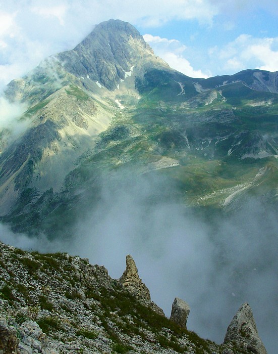
Gran Sasso and Monti della Laga National Park
42.4907° N · 13.4952° E · National Park
Photo: Idéfix at Dutch Wikipedia · CC BY-SA 3.0 · Wikimedia Commons
Gran Sasso and Monti della Laga National Park is an Italian national park. It is near Marche, Italy. The national park was established in 1991. The free Lokali audio guide runs 7 minutes.
✓ Published October 2026 · how we write these guides
Visitor facts
| Lokali audio guide | 7 min · free |
|---|---|
| Type | National Park |
| Location | Marche, Italy |
| Coordinates | 42.4907, 13.4952 |
| Official website | gransassolagapark.it |
| Languages | 50+, in the Lokali app |
The story
Listen first. Up here the wind moves through short grass with a dry, steady hiss. A cowbell rings somewhere you cannot see. The air smells of thyme and cold stone, and the light is hard and clear, the kind of light that makes distant ridges look close enough to touch. You are standing in one of the largest protected landscapes in Italy, where the Apennine mountains, the long spine that runs down the length of the country, reach their highest point.
The park was created in 1991 and covers a wide arc of the central Apennines. Most of it lies in Abruzzo, but its borders also reach into Lazio and into Marche, the region you are exploring. That makes it a meeting place of three regions, three dialects, and three kitchens. The name holds two separate mountain worlds. Gran Sasso means the Great Rock. Monti della Laga are the Laga Mountains. The two look and feel completely different, and that contrast is the first surprise of this place.
Start with the rock. The Gran Sasso massif is made mostly of limestone, pale grey and sometimes almost white in strong sun. Its highest summit, Corno Grande, rises to about 2,912 metres. No peak in the Apennines stands higher. From certain angles the mountain looks less like an Italian hill range and more like the Dolomites, with sharp walls, scree slopes, and deep gullies. On very clear days, people on the summit report seeing both the Adriatic Sea and the Tyrrhenian Sea.
Here is a detail many visitors miss. Tucked into a shaded hollow below Corno Grande lies the Calderone, a small body of ice that was long described as the southernmost glacier in Europe. Over recent decades it has shrunk dramatically. Scientists now describe it as split into two small glacierets, ice patches too small to be called a true glacier. It is a quiet and very visible measure of a warming climate, sitting on the doorstep of the Mediterranean.
Now turn toward the north, toward Marche. The Laga Mountains are built from a different material — sandstone and marl, a soft clay-rich rock laid down in layers. Limestone lets water sink underground, but these rocks hold water near the surface. The result is a landscape of streams, beech forests, and waterfalls. In late spring, when the snow melts, white water pours down the slopes in long ribbons. Walk here, and you hear running water almost everywhere.
Between these two worlds lies one of the strangest spaces in Italy. Campo Imperatore is a vast high plateau, flat and open, stretching for many kilometres at roughly the height of a small Alpine peak. Italians sometimes call it Little Tibet. There are almost no trees. Grass, wildflowers, and grazing animals fill the view. Film crews have used it as a stand-in for the American West, and when you see the long empty road crossing it, you understand why.
The plateau also holds a sharp piece of twentieth-century history. In 1943, after Mussolini was removed from power, he was held prisoner at a hotel near the top of Campo Imperatore. In September of that year, German forces landed gliders on the mountain and freed him in a daring raid. The hotel building still stands near the upper station of the cable car. Today hikers drink coffee where one of the strangest episodes of the Second World War took place.
For centuries, though, the true rulers of these mountains were shepherds. Each summer, huge flocks of sheep climbed to the high pastures. Each autumn they walked down to the warmer plains of Puglia, far to the south, along wide grassy tracks called tratturi. This seasonal migration is called transhumance, and it shaped the economy, the villages, and even the castles of the region. Wool from these flocks once travelled across Europe. You can still meet shepherds and their large white guard dogs on the open slopes.
Those dogs matter, because wolves live here. The Apennine wolf survived in these mountains when it vanished from much of Europe. The park is also home to golden eagles, wild boar, and a rare mountain goat called the Apennine chamois. That chamois had disappeared from the area, and conservation teams brought it back in the 1990s. Today small herds graze the high cliffs of the Gran Sasso. Bring binoculars, look at the rocky ledges, and be patient.
The human villages are as striking as the wildlife. On the Abruzzo side, the ruined fortress of Rocca Calascio sits on a bare ridge, one of the highest castles in Italy. Nearby, Santo Stefano di Sessanio is a stone village where many houses have been carefully restored. On the Marche side, small communities around Acquasanta Terme and Arquata del Tronto sit in deep green valleys. Acquasanta is known for its warm springs, a tradition that goes back to Roman times.
This is also a landscape that has suffered. The earthquakes of 2016 struck hard across the Laga area, and towns such as Amatrice and Arquata del Tronto were badly damaged. In some villages you will see scaffolding, empty lots, and new buildings beside cracked old walls. Rebuilding is slow and ongoing. Spending time and money in local inns, cafés, and farm shops is one of the most direct ways a visitor can help these communities recover.
One more surprise lies hidden under your feet. Deep inside the Gran Sasso, reached through the motorway tunnel that crosses the massif, is one of the largest underground physics laboratories in the world. Scientists work there beneath more than a kilometre of rock. The mountain acts as a shield against cosmic rays, so researchers can study tiny particles such as neutrinos and search for dark matter. While shepherds graze sheep above, physicists study the universe below.
And then there is the food. Mountain pastures produce strong sheep's cheese, especially pecorino. Lentils from the high plateaus are small and earthy. Around Campo Imperatore, small grills cook arrosticini, thin skewers of mutton or lamb, eaten hot with bread and red wine. On the Marche side, chestnuts, mushrooms, and truffles appear in autumn. Each valley has its own recipes, and locals take quiet pride in them.
Before you move on, stand still for a moment. Notice the colour of the rock near you — pale limestone or darker sandstone. Listen for water, or for the wind alone. Look at the line of the ridges against the sky, and at any track worn into the grass by many generations of hooves. These mountains have held shepherds, soldiers, scientists, and travellers like you. As you walk away, keep listening. The bell you heard at the start is probably still ringing.
Key facts
What to look for
Practical tips
Common questions
Is there a free audio guide to Gran Sasso and Monti della Laga National Park?
Yes — the Lokali app narrates Gran Sasso and Monti della Laga National Park free of charge in 50+ languages. The guide runs about 7 minutes, covers the history, what to look for on site and practical tips, and works offline once downloaded.
Where is Gran Sasso and Monti della Laga National Park?
Gran Sasso and Monti della Laga National Park is near Marche, Italy, at 42.4907, 13.4952. Tap the map link on this page for directions from where you are.
What is Gran Sasso and Monti della Laga National Park known for?
The national park was established in 1991. Corno Grande reaches about 2,912 metres, the Apennines' highest point.
What should you look for at Gran Sasso and Monti della Laga National Park?
Pale grey limestone walls rising above Campo Imperatore. Long ribbons of waterfalls on Laga sandstone slopes. Old grassy transhumance tracks crossing the high pastures.
What should you know before visiting Gran Sasso and Monti della Laga National Park?
Visit Laga waterfalls in late spring during snowmelt. Pack warm layers even in summer at high altitude.
When is the best time to visit Gran Sasso and Monti della Laga National Park?
Visit Laga waterfalls in late spring during snowmelt.
On the map
Opens directions to Gran Sasso and Monti della Laga National Park from your location.
More to see near Gran Sasso and Monti della Laga National Park


Hear Gran Sasso and Monti della Laga National Park in your language
The full story, narrated, in 50+ languages. Download it before you go and it plays offline, at your own pace, with no ticket and no tour group.