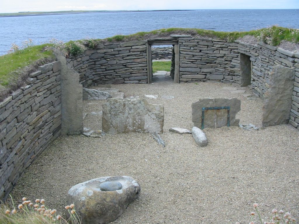
Knap of Howar
59.3493° N · 2.9108° W · Archaeological Site
Photo: Wikimedia Commons contributor · CC BY-SA 3.0 · Wikimedia Commons
Knap of Howar is the oldest stone house in northwest Europe. It is near Orkney Islands, United Kingdom. Neolithic farmstead occupied over five thousand years ago. The free Lokali audio guide runs 6 minutes.
✓ Published October 2026 · how we write these guides
Visitor facts
| Lokali audio guide | 6 min · free |
|---|---|
| Type | Archaeological Site |
| Location | Orkney Islands, United Kingdom |
| Coordinates | 59.3493, -2.9108 |
| Languages | 50+, in the Lokali app |
The story
Listen first. The wind comes in off the Atlantic and moves through the dune grass. Gulls call somewhere over the shore, and under your boots the turf is soft and springy. In front of you, two low stone buildings sit half-sunk into the ground, their walls the grey of wet slate. They look modest. But you are standing beside some of the oldest houses still standing anywhere in northern Europe.
This is the Knap of Howar, on the west coast of Papa Westray, one of the smaller northern isles of Orkney. The buildings date from the Neolithic period, the age of the first farmers. People lived here more than five thousand years ago. That makes these homes older than the pyramids of Giza. They are also older than the more famous Neolithic village of Skara Brae, on Orkney's mainland.
For most of those five thousand years, nobody knew the houses were here. Sand blew in from the shore and buried them completely. The dunes kept the stone safe from wind, frost and human hands. Then erosion began to strip the sand away, and walls started to show through. In the 1930s, the site was cleared and excavated for the first time. The name Knap of Howar is usually explained as Norse in origin, meaning roughly the knoll of the mounds.
A second, more careful excavation came in the 1970s, led by the archaeologist Anna Ritchie. Her team used modern methods, including radiocarbon dating, to work out how old the buildings really were. The results surprised many people. The houses belonged to a very early phase of farming life in Orkney. Ritchie's work turned a curious ruin into one of the key sites for understanding the first farming communities of the far north.
Now look at the layout. There are two buildings, set side by side and joined by a short passage. The larger one, closer to the sea, was the main house. The smaller one sits behind it. Both are long and rounded at the ends, a little like an upturned boat. The walls are built from flat local stone, stacked without mortar, and they still stand to around shoulder height.
Here is a detail many visitors miss. The houses were not built on bare ground. The builders dug them into an older rubbish heap, called a midden, made of ash, shells, bones and earth. This was a clever choice. The packed midden acted like insulation, holding the walls firm and keeping out the cold. In a place this windy, a house wrapped in its own old rubbish was a warm house.
Step down into the larger building if you can. Notice how the entrance is low, and you have to stoop to pass through. Inside, upright stone slabs divide the space into two rooms. The first room was probably the living area, with a hearth and space to work. Stone benches line the walls. Try to imagine the room with a fire burning, a turf roof above, and smoke drifting up through the dim light.
The smaller building behind feels different. It is divided into three compartments, and its walls hold recesses that look like built-in cupboards and shelves. Archaeologists think it served as a workshop, a store, or both. Tools were made and mended here. Food may have been kept here, away from the main living space. It is a practical, organised home, laid out by people who thought carefully about how to use every corner.
The finds from the excavations tell us how these people lived. They kept cattle, sheep and pigs. They grew cereal crops and ground the grain on flat stones called saddle querns, rubbing one stone against another. They also took food from the sea, gathering shellfish and catching fish. Their pottery was of a style called Unstan ware, named after a tomb on mainland Orkney, with shallow bowls and decorated rims.
Here is a second surprise. Papa Westray is a small island today, but the people of the Knap of Howar were not cut off from the wider world. Orkney in this period was a busy place. Farmers built great chambered tombs and, later, stone circles. Boats would have moved goods and people between the islands. This farm was part of a network of communities that shared tools, pottery styles and ideas across the sea.
The landscape has changed since then. Scholars believe the coast here once looked quite different, and the farm may have stood further from the open shore than it does now. Sea levels shifted. Sand moved. The same dunes that later buried the houses were part of that slow change. Today, the sea is close, and you can see the island of Westray across the water to the west on a clear day.
Getting here is part of the story. Many visitors reach Papa Westray by ferry. Others take the flight from Westray, often described as the shortest scheduled passenger flight in the world, lasting only a minute or two in good weather. Either way, you arrive on an island of farms, stone dykes and open sky. The Knap of Howar sits quietly among the fields, with no crowds and very few signs of the modern world.
Before you leave, stand back from the walls for a moment. Look at the line where the stone meets the grass. Look at the rounded corners, shaped by people who had no metal tools. Listen again to the wind and the sea. These are the same sounds the first farmers heard from inside these walls. As you walk back across the fields, you are following a path that people have used, in one way or another, for five thousand years.
Key facts
What to look for
Practical tips
Common questions
Is there a free audio guide to Knap of Howar?
Yes — the Lokali app narrates Knap of Howar free of charge in 50+ languages. The guide runs about 6 minutes, covers the history, what to look for on site and practical tips, and works offline once downloaded.
Where is Knap of Howar?
Knap of Howar is near Orkney Islands, United Kingdom, at 59.3493, -2.9108. Tap the map link on this page for directions from where you are.
What is Knap of Howar known for?
Neolithic farmstead occupied over five thousand years ago. Among the oldest standing houses in northern Europe.
What should you look for at Knap of Howar?
Upright stone slabs dividing the main house into rooms. Wall recesses shaped like cupboards in the smaller building. The short connecting passage linking the two buildings.
What should you know before visiting Knap of Howar?
Wear waterproof boots for the wet fields and dune grass. Bring a windproof layer, even on bright summer days.
When is the best time to visit Knap of Howar?
Bring a windproof layer, even on bright summer days.
On the map
Opens directions to Knap of Howar from your location.
More to see near Knap of Howar


Hear Knap of Howar in your language
The full story, narrated, in 50+ languages. Download it before you go and it plays offline, at your own pace, with no ticket and no tour group.