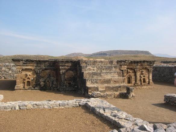
Photo: not stated · CC BY-SA 1.0 · Wikimedia Commons
Taxila is an archaeological site of the ancient Indian subcontinent, at Taxila, Punjab, Pakistan. UNESCO added Taxila to the World Heritage List in 1980. The free Lokali audio guide runs 7 minutes.
✓ Published October 2026 · how we write these guides
Visitor facts
| Lokali audio guide | 7 min · free |
|---|---|
| Type | Archaeological Site |
| Location | Rawalpindi, Pakistan |
| Coordinates | 33.7458, 72.7875 |
| Languages | 50+, in the Lokali app |
The story
Start with your feet. The ground here is dry, pale earth, scattered with chips of stone and old brick. A warm wind comes down from the low hills, and it carries the smell of dust and wild grass. Somewhere a bird calls from an acacia tree. All around you, knee-high walls run in straight lines across the fields. They look modest at first. But you are standing in one of the oldest cities in South Asia — a place where Greek, Persian, Indian and Central Asian worlds met.
This is Taxila. It lies in the Rawalpindi District of northern Pakistan, less than an hour's drive from the modern capital, Islamabad. In 1980, UNESCO added it to the World Heritage List. Taxila is not one single ruin. It is a whole valley of them. There are three separate city sites, built one after another over many centuries. There are also dozens of Buddhist monasteries and stupas in the surrounding hills. A stupa, by the way, is a dome-shaped Buddhist monument that holds sacred relics.
Why here? Look at the land. The valley sits on old trade routes that linked the plains of India with Central Asia and Persia. Merchants, soldiers and pilgrims all had to pass this way. Water came from small rivers, and the hills gave shelter. In ancient times this region was called Gandhara. That name matters, because Gandhara gave the world a new kind of art — and you will meet it everywhere at Taxila.
The oldest of the three cities is called the Bhir Mound. Archaeologists date its first settlement to around the sixth century before Christ. At that time this region was part of the Persian Achaemenid Empire, the great dynasty of Cyrus and Darius. Walking the Bhir Mound today, you will notice something. The streets are crooked and narrow. They twist without a clear plan. This was a city that grew slowly, house by house, the way old towns usually do.
In 326 BC, Alexander the Great arrived. Greek writers record that the local ruler, whom they called Taxiles, chose not to fight. Instead he welcomed Alexander and offered him gifts and support. The Greek army rested here before moving on toward the Indus battles further east. Alexander did not stay long. But Greek influence did not leave with him. A century and more later, Greek kings ruled this land again — and they built a new city.
That city is Sirkap, and it is the one most visitors remember. Here is the first surprise. Unlike the tangled Bhir Mound, Sirkap is laid out on a grid. One long main street runs straight through the city, and smaller lanes cross it at right angles. This is a Greek town plan, carried thousands of kilometres east. Walk down that main street now. On both sides are the low foundations of shops, houses and shrines.
Look for one shrine in particular. It is known as the Shrine of the Double-Headed Eagle. Its base carries small carved facades side by side. One looks like the front of a Greek temple, with a triangular pediment. Another has the curved arch of an Indian gateway. Above one niche sits a small eagle with two heads. Three traditions, on one little platform. Few places in the world show cultural mixing so clearly, in so small a space.
Notice the walls themselves, too. Many of Taxila's buildings use a style that archaeologists call diaper masonry. Builders set large, roughly shaped stones in rows. Then they packed the gaps with neat stacks of small, flat stones. The result looks like a patterned cloth. Over the centuries, the technique changed, and experts use these changes to help date different buildings. So the walls are not just walls. They work like a timeline written in stone.
The third city, Sirsukh, came later, under the Kushans. The Kushans were a dynasty from Central Asia who built a large empire across this region in the early centuries after Christ. Under their rule, Buddhism flourished at Taxila. Monasteries spread across the hills. Pilgrims came from far away. And Gandhara art reached its peak. This art showed the Buddha with wavy hair and flowing robes, much like a Greek statue — a style that later travelled along the Silk Road.
One of the most important Buddhist sites is the Dharmarajika stupa. Tradition links its founding to Ashoka, the great Mauryan emperor of the third century before Christ, who promoted Buddhism across his lands. Around the main stupa is a ring of smaller stupas and chapels. Further into the hills is the monastery of Jaulian. Its stucco figures of the Buddha still sit in rows around the courtyard, with soft faces and folded hands.
At Jaulian, look for the second surprise. One seated Buddha figure has a small hole at its navel. Locals call it the Healing Buddha. According to a popular belief, pilgrims placed a finger in the hole and prayed to be cured of illness. Whether that practice is ancient or more recent is not certain. But even today, visitors pause in front of this figure longer than the others. Nearby, at Mohra Moradu, a small stupa survives almost complete.
Much of what we know about Taxila comes from long excavations led by Sir John Marshall in the early twentieth century. He and his teams worked here for many years. They uncovered streets, coins, jewellery and sculpture. Many of these finds are now in the Taxila Museum, close to the ruins. Chinese Buddhist pilgrims also left written accounts. By the time the monk Xuanzang came in the seventh century, he described a place largely in ruin.
There is also a tradition that Taxila was a great centre of learning in the ancient world. Indian texts connect it with teachers and scholars, including Chanakya, the political thinker said to have advised the Maurya dynasty. Historians still discuss how this learning was organised. It was probably not a single university with buildings and halls, as we imagine today. More likely, teachers gathered students around them. The fame of the place travelled across India.
Now look around you once more. The walls are low, the fields are quiet, and the hills rise softly in the distance. It is easy to walk past a line of stones without a second thought. But Persian officials, Greek kings, Kushan rulers and Buddhist monks all walked here. As you leave, notice the dust on your shoes. It is the same pale earth that covered these cities for centuries — and kept them safe until someone looked closely.
Key facts
What to look for
Practical tips
Common questions
Is there a free audio guide to Taxila?
Yes — the Lokali app narrates Taxila free of charge in 50+ languages. The guide runs about 7 minutes, covers the history, what to look for on site and practical tips, and works offline once downloaded.
Where is Taxila?
Taxila is near Rawalpindi, Pakistan, at 33.7458, 72.7875. Tap the map link on this page for directions from where you are.
What is Taxila known for?
UNESCO added Taxila to the World Heritage List in 1980. Bhir Mound settlement dates to around the sixth century BCE.
What should you look for at Taxila?
The Double-Headed Eagle shrine on Sirkap's main street. Diaper masonry walls with small stones packed between large ones. The Healing Buddha with a hole at its navel.
What should you know before visiting Taxila?
Visit the Taxila Museum first to understand the scattered sites. Arrange a car or driver to reach the hilltop monasteries.
When is the best time to visit Taxila?
Come early morning to avoid the strong midday heat.
On the map
Opens directions to Taxila from your location.
More to see near Taxila


Hear Taxila in your language
The full story, narrated, in 50+ languages. Download it before you go and it plays offline, at your own pace, with no ticket and no tour group.