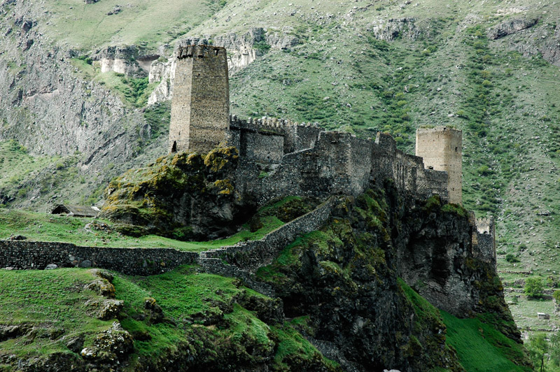
Khertvisi Fortress
41.4796° N · 43.2857° E · Fortification
Photo: Laurynas M. from Vilnius, Lithuania · CC BY 2.0 · Wikimedia Commons
Khertvisi Fortress are fortresses in Georgia. Stands where the Mtkvari and Paravani rivers meet. The free Lokali audio guide runs 6 minutes.
✓ Published October 2026 · how we write these guides
Visitor facts
| Lokali audio guide | 6 min · free |
|---|---|
| Type | Fortification |
| Location | Samtskhe–Javakheti, Georgia |
| Coordinates | 41.4796, 43.2857 |
| Languages | 50+, in the Lokali app |
The story
Listen first. Below you, two rivers meet. The water is loud here, a steady rush over stone that never quite stops. The air smells of dry grass, warm rock, and sometimes woodsmoke from a village kitchen. Above you, pale walls climb a narrow ridge of rock and follow every bend of it. This is Khertvisi Fortress, in the south of Georgia. People have used this outcrop as a stronghold for a very long time. Before any dates or names, take a moment to feel how high and exposed it is.
The location explains almost everything. Khertvisi stands on a rocky spur where the Mtkvari River meets the Paravani. The Mtkvari is the great river of Georgia. It runs on through Tbilisi and far beyond. The Paravani comes down from the high Javakheti plateau. Where two valleys join, roads join too. Whoever held this rock could watch traffic coming from several directions at once. Merchants, armies, and shepherds all had to pass below these walls.
Khertvisi is often counted among the oldest fortresses in Georgia. Georgian tradition says that a stronghold stood here as early as the second century before Christ. That claim comes from old chronicles and tradition, not from a single excavation. Historians treat it with care. Even so, the site has clearly carried defenses for many centuries. The stone you see today belongs to much later rebuilding. It is the latest layer on a very old foundation.
There is a famous story here. Legend has it that Alexander the Great came through this region and destroyed the fortress. Local people still tell the tale with some pride. Historians doubt it, because no firm evidence places Alexander in this valley. The story is folklore. It shows something real, though. For centuries, people wanted to connect this rock with the greatest conqueror they knew. Keep the legend in mind as a story, not a record.
Now look at the walls themselves. Most of the visible fortress dates from roughly the tenth to the fourteenth centuries. It was the medieval era, when Georgian kingdoms rebuilt and strengthened their borderlands. The builders used local stone, rough and grey-brown, set in thick courses. Notice how the walls do not follow a neat plan. They follow the rock. Where the ridge narrows, the fortress narrows. Where the cliff drops away, the builders let the cliff do the work.
Here is something many visitors miss. Khertvisi is really two parts. On the highest point sits the citadel, the inner core, with its strongest towers. Below it, a longer line of walls encloses a lower area along the ridge. Defenders could fall back from the outer walls to the citadel if attackers broke through. As you walk, try to see the fortress as a series of rings. Each ring was a last chance to hold out.
Inside the walls there is a small church. Its presence is a reminder that a fortress was more than a military post. Soldiers, officials, and their families lived here, and they prayed here. In medieval Georgia, faith and defense were closely tied. The Georgian Orthodox Church was central to the identity of the people who held this rock. A church inside the walls meant that the community, not only the garrison, was protected.
In the twelfth and thirteenth centuries, this region of Meskheti was part of a strong Georgian kingdom. That period is often called the Georgian golden age. Khertvisi served as an important regional center at that time. A short drive further up the Mtkvari valley lies Vardzia, the great cave monastery cut into a cliff. Khertvisi and Vardzia belong to the same story. One guarded the valley with walls. The other sheltered monks and people deep inside the rock.
The centuries that followed were harder. Mongol invasions swept across Georgia, and the kingdom later split into smaller states. Then, in the sixteenth century, the Ottoman Empire took control of this border region. For roughly two and a half centuries, Khertvisi stood on the Ottoman side of a contested frontier. The fortress changed hands, but the logic of the rock stayed the same. Whoever ruled here still needed to watch the rivers.
That chapter ended in the nineteenth century. During the Russo-Turkish war of 1828 and 1829, Russian forces took this part of southern Georgia. The region became part of the Russian Empire. After that, the frontier moved away, and Khertvisi slowly lost its military purpose. Walls that once mattered a great deal became quiet ruins. Today, the main visitors are travellers, photographers, and families on the road to Vardzia.
As you climb, pay attention to your feet. The path is uneven, and the rock can be smooth and slippery. Good shoes help a lot here. Stop at the gaps in the wall and look down. You can follow the line of the old road along the river. You can see small fields and gardens on the narrow valley floor. On a clear day, the bare, brown hills seem to fold away in every direction.
The light changes this place completely. In the middle of the day, the stone looks pale and almost flat. Late in the afternoon, the walls turn warm and golden, and the shadows sharpen every tower. Wind often moves through the gaps in the stone. You may hear birds nesting in the crevices high above. You may also hear a car crossing the bridge below, a small modern sound against very old walls.
Before you leave, stand still for one more minute. Look at the point where the two rivers meet. That meeting of water is the reason this fortress exists. Everything else came after it: the legends, the towers, the church, the empires that came and went. As you walk back down, listen again to the rush of the river. It is the same sound the guards heard from these walls, centuries ago.
Key facts
What to look for
Practical tips
Common questions
Is there a free audio guide to Khertvisi Fortress?
Yes — the Lokali app narrates Khertvisi Fortress free of charge in 50+ languages. The guide runs about 6 minutes, covers the history, what to look for on site and practical tips, and works offline once downloaded.
Where is Khertvisi Fortress?
Khertvisi Fortress is near Samtskhe–Javakheti, Georgia, at 41.4796, 43.2857. Tap the map link on this page for directions from where you are.
What is Khertvisi Fortress known for?
Stands where the Mtkvari and Paravani rivers meet. Tradition dates a stronghold here to the second century BCE.
What should you look for at Khertvisi Fortress?
The upper citadel towering over the lower wall circuit. Walls bending to follow the natural line of rock. The small church sheltered inside the fortress walls.
What should you know before visiting Khertvisi Fortress?
Wear sturdy shoes for the uneven, slippery rock path. Visit late afternoon for warm light on the walls.
When is the best time to visit Khertvisi Fortress?
Bring water and sun protection on exposed summer days.
On the map
Opens directions to Khertvisi Fortress from your location.
More to see near Khertvisi Fortress


Hear Khertvisi Fortress in your language
The full story, narrated, in 50+ languages. Download it before you go and it plays offline, at your own pace, with no ticket and no tour group.