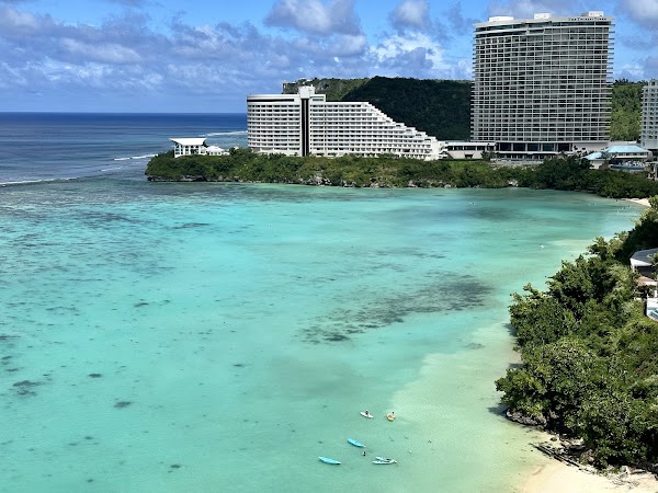
Tumon Bay is a wide, crescent-shaped beach in central Guam bordered by resort hotels and framed by coral reefs. It is in Tumon, United States. Most visitors spend 1–3 hours here. The free Lokali audio guide runs 5 minutes.
✓ Verified August 2026 · how we write these guides
Visitor facts
| Time needed | 1–3 hours |
|---|---|
| Lokali audio guide | 5 min · free |
| Type | Beach |
| Best for | Family |
| Location | Tumon, United States |
| Coordinates | 13.6400, 144.8050 |
| Languages | 45, in the Lokali app |
The story
Step off the sand into the water and notice how calm it is. The lagoon lies flat as poured glass, warm as a bath, and the color of pale jade. Far out, a white line of surf marks the reef. Coconut palms lean over the sand, and hotel towers stand in a quiet row behind them. This is Tumon Bay, Guam's famous crescent, where the island meets the Pacific with almost no waves at all.
The bay draws a long crescent between two headlands. To the north rises the cliff of Two Lovers Point. To the south sits Ypao Point, with a public beach park behind it. Between them runs a ribbon of white coral sand, backed by a line of high-rise hotels along Pale San Vitores Road.
The calm is not luck. A fringing coral reef crosses the mouth of the bay like a low wall. Ocean swells break out there on the reef crest and spend their force before they reach you. Inside the wall, the lagoon stays shallow and gentle. Small children float in it, and swimmers cross it like a pool. In many places the water reaches only your knees or your chest at low tide.
Since 1997, these waters have carried extra protection. That year Guam declared Tumon Bay a marine preserve, one of five created around the island. Fishing inside is tightly limited. In the years that followed, fish numbers grew, and snorkelers noticed the change. Today the lagoon works as a nursery, where young reef fish grow up in relative safety.
Bring a mask if you can. The clearest water usually comes in the morning, before the wind picks up. Over the sand you may find sea cucumbers lying still like dark loaves. Near coral heads, sergeant majors flash yellow and black stripes, and parrotfish scrape algae with beaks you can actually hear underwater. Sea turtles pass through on occasion. Give every animal room, and never stand on coral.
People lived along this bay long before any hotel. Tumon was a CHamoru village site for many centuries, back into the era when houses stood on carved stone pillars called latte. Builders digging hotel foundations here have uncovered ancient burials and village remains, and those finds confirmed how long people have called this shore home.
One event here changed Guam's history. In 1672, the Jesuit missionary Diego Luis de San Vitores was killed at Tumon after a conflict with a local leader named Matå'pang. San Vitores had founded the Spanish mission on Guam four years earlier. His death set off decades of war between Spain and the CHamoru people, and the island that emerged was never the same.
The modern chapter began with an airplane. In 1967, the first commercial tourist flights arrived from Japan. Hotels rose along the sand in the decades that followed, and Tumon grew into the island's tourism district. Today the strip behind the beach holds resorts, duty-free malls, restaurants, and nightlife. Most visitors still come from Japan and Korea, and signs along the strip appear in several languages.
At the southern end, Ypao Beach Park belongs to everyone. It is a public park with pavilions, barbecue pits, and wide lawns under palm and ironwood trees. On weekends, local families claim the tables early, and the smell of grilled chicken drifts down the beach. Ypao also hosts festivals and outdoor concerts through the year. It is the easiest place on the bay to meet Guam at rest.
You can walk the whole crescent along the sand. The shore stays public even where hotels stand behind it, and paths between buildings connect the beach to the road. Go at low tide, when the firm wet sand makes an easy road. Morning joggers use the same route before the heat arrives. The full walk takes about an hour each way at a slow pace.
Stay for the end of the day. The bay faces west, so the sun sets over the open sea, behind the reef line. The lagoon turns from jade to copper to gray. Dinner shows begin at several resorts, with fire dances and island drums, and the water holds the last color long after the sun is gone.
As you leave, look once more at the calm water. The same lagoon carried outrigger canoes, mission boats, and now swimmers from around the world. The reef still stands its old watch offshore. Centuries pass, and the waves still break out there, at a polite distance.
Key facts
What to look for
Practical tips
Common questions
How long do you need at Tumon Bay?
Plan 1–3 hours. That is the time most visitors spend at Tumon Bay. The free Lokali audio guide adds about 5 minutes of narration you can listen to as you walk, so it fits inside your visit rather than adding to it.
Is there a free audio guide to Tumon Bay?
Yes — the Lokali app narrates Tumon Bay free of charge in 50+ languages. It covers the history, what to look for on site and practical tips, and it works offline once downloaded.
Where is Tumon Bay?
Tumon Bay is in Tumon, United States, at 13.6400, 144.8050. Tap the map link on this page for directions from where you are.
What should you know before visiting Tumon Bay?
Swim at mid or high tide for deeper water.
What is Tumon Bay known for?
Guam declared Tumon Bay a marine preserve in 1997.
What is the best time to visit Tumon Bay?
The reef edge closest to shore holds small fish and sea turtles.
On the map
Opens directions to Tumon Bay from your location.
More to see in Tumon


Hear Tumon Bay in your language
The full story, narrated, in 50+ languages. Download it before you go and it plays offline, at your own pace, with no ticket and no tour group.