
Two Lovers Point is a scenic clifftop overlook on the northern tip of Guam, marked by a white cross and surrounded by lush vegetation. It is in Tumon, United States. Most visitors spend 30–45 min here. The free Lokali audio guide runs 5 minutes.
✓ Verified August 2026 · how we write these guides
Visitor facts
| Time needed | 30–45 min |
|---|---|
| Lokali audio guide | 5 min · free |
| Type | Viewpoint |
| Best for | Photography |
| Location | Tumon, United States |
| Coordinates | 13.6347, 144.8006 |
| Languages | 45, in the Lokali app |
The story
Stand at the railing and feel the wind climb the cliff. Far below, the Philippine Sea moves in slow bands of turquoise and deep blue. Waves fold against the rock without a sound, because the water is about 120 meters down. This is Two Lovers Point, the high northern anchor of Tumon Bay and the most visited lookout on Guam. The lookout crowns the island's northwest shoulder, where the hotel district gives way to open coast.
In the CHamoru language, this place is called Puntan Dos Amantes. It means the point of the two lovers. The name comes from a legend, and the legend is the reason this cliff matters so deeply to the island. Families here have told the story for generations, and they tell it as their own.
The story is set in the Spanish colonial era. A young woman from a proud Hagåtña family was promised in marriage to a powerful Spanish captain. She did not choose him, and she did not love him. She loved a young CHamoru man from a modest family. Her father refused their match and set a wedding date anyway.
The two lovers ran north along the coast. Soldiers followed. The land ended here, at this cliff, with the sea far below and no way down. The couple tied their long black hair together into one knot. They kissed, stepped to the edge, and leapt as one. That is the legend. No document proves it happened, but the island has kept the story alive for centuries.
The legend shapes everything you see on the platform. Look at the fences around the viewing deck. Thousands of padlocks hang from the mesh, and many are shaped like hearts. Couples write their names on a lock, click it shut, and leave it behind as a promise. Nearby hangs a bell. Visitors ring it in pairs, two hands pulling one rope.
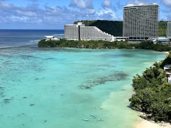
The observation deck is the main event. It stands at the cliff edge and looks south over the full curve of Tumon Bay. The hotel towers line the shore like a row of pale bookends. On a clear day you can trace the reef line, where the shallow lagoon ends and the open ocean begins. Behind you, to the north, the limestone coast runs green and wild toward Ritidian at the island's tip.
Study the water colors for a moment. Inside the reef, the lagoon glows green and turquoise, because the sandy bottom sits only a meter or two below the surface. Beyond the reef, the seafloor drops away fast, and the blue turns almost black. The border between the two looks sharp enough to be drawn with a ruler. The lagoon below is part of a marine preserve created in 1997, and its reef life has recovered strongly since.
The point itself is a small park. There is a gift shop with charms and love locks, a cafe, and a little chapel used for weddings. Couples travel from Japan and Korea to marry here, above the sea from the story. The observation deck charges a small admission fee, and the rest of the grounds are free to walk.
The rock under your feet has its own long story. Northern Guam is a raised plateau of coral limestone. This cliff was once a living reef beneath the sea. Over a very long time, the island rose, and the old reef became stone standing in the air. Rain now soaks through that porous rock and feeds the aquifer that supplies most of the island's drinking water.
The wind here rarely rests. Trade winds cross thousands of kilometers of open Pacific and meet this cliff first. Hold your hat, and hold your phone with both hands over the rail. Bring water, because shade is limited and the sun reflects hard off the sea. Late afternoon brings the best light. The deck faces the sunset, so the final hour of the day is the busiest and the most beautiful.
Think about why the legend has lasted. It is a story about loyalty standing against power. For CHamorus, it carries the memory of the colonial era, when foreign rule reached into family life, marriage, and land. Keeping the story alive became a quiet way of remembering who the island's people were and who they still are. Grandparents tell it to children on this same deck.
Before you leave, stand at the rail one more time. Watch the swells arrive in long, patient lines. The legend says the lovers were never separated and never found. The sea below keeps that secret. It has kept it for centuries, and it is not telling today.
Key facts
What to look for
Practical tips
Common questions
How long do you need at Two Lovers Point?
Plan 30–45 min. That is the time most visitors spend at Two Lovers Point. The free Lokali audio guide adds about 5 minutes of narration you can listen to as you walk, so it fits inside your visit rather than adding to it.
Is there a free audio guide to Two Lovers Point?
Yes — the Lokali app narrates Two Lovers Point free of charge in 50+ languages. It covers the history, what to look for on site and practical tips, and it works offline once downloaded.
Where is Two Lovers Point?
Two Lovers Point is in Tumon, United States, at 13.6347, 144.8006. Tap the map link on this page for directions from where you are.
What should you know before visiting Two Lovers Point?
Arrive about an hour before sunset for the best light.
What is Two Lovers Point known for?
CHamoru name Puntan Dos Amantes means point of two lovers.
What is the best time to visit Two Lovers Point?
Visit at sunrise or late afternoon when the light softens the cliffs.
On the map
Opens directions to Two Lovers Point from your location.
More to see in Tumon


Hear Two Lovers Point in your language
The full story, narrated, in 50+ languages. Download it before you go and it plays offline, at your own pace, with no ticket and no tour group.