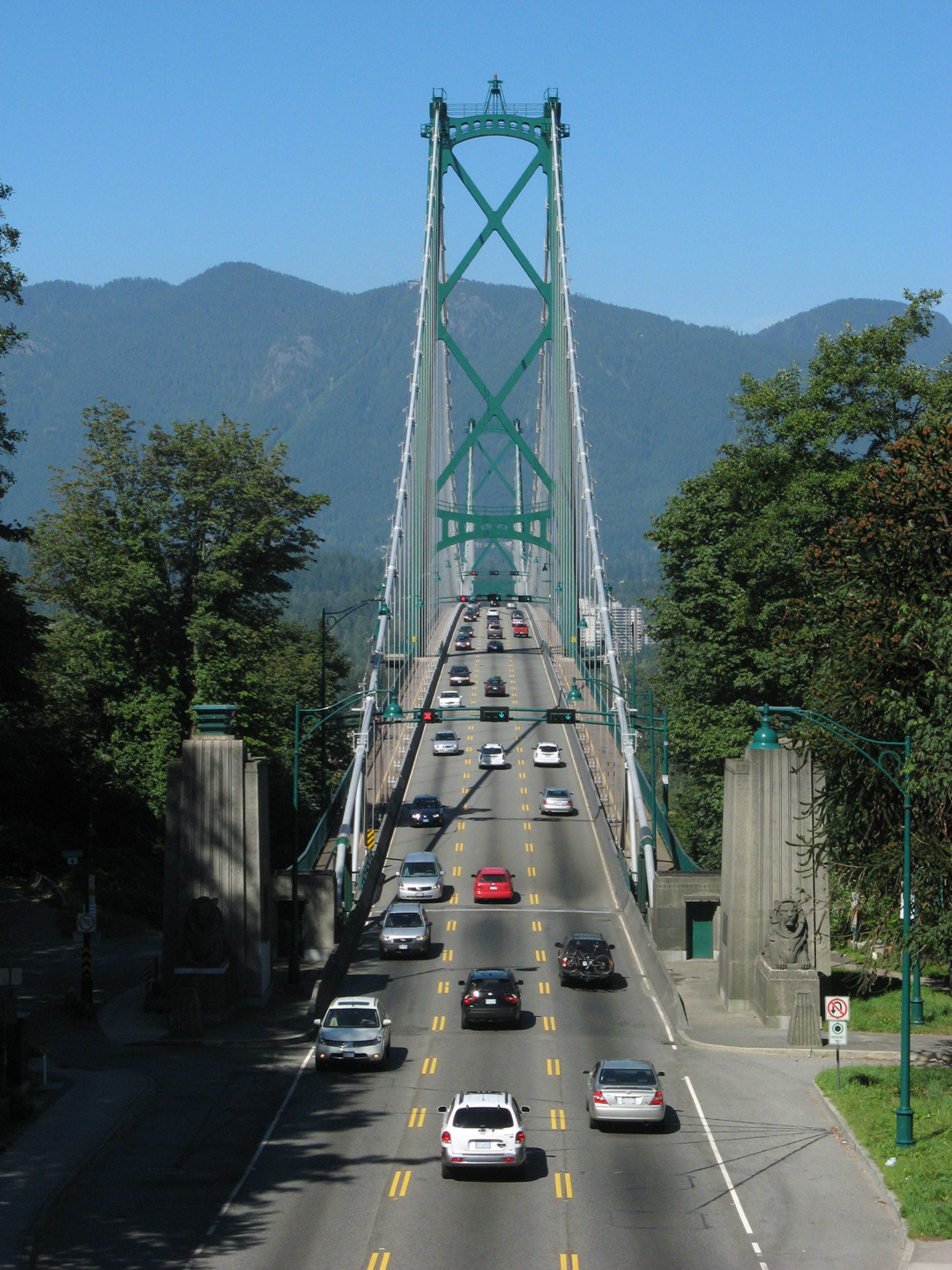
Photo: Bobanny · Public domain · Wikimedia Commons
Lions Gate Bridge is a suspension bridge in Vancouver, Canada. Opened in 1938 as the First Narrows Bridge. The free Lokali audio guide runs 7 minutes.
✓ Published October 2026 · how we write these guides
Visitor facts
| Lokali audio guide | 7 min · free |
|---|---|
| Type | Bridge |
| Location | Vancouver, Canada |
| Coordinates | 49.3153, -123.1383 |
| Languages | 50+, in the Lokali app |
The story
Stand still for a moment and feel it. The steel deck under your feet carries a faint, steady hum. Car tires thrum across the joints. Far below, the tide pulls hard through a narrow channel of green-grey water. And the air smells of salt, cedar, and diesel all at once. This is the Lions Gate Bridge, and it is moving very slightly beneath you right now.
The bridge crosses a stretch of water called the First Narrows. This is the tight entrance to Burrard Inlet, the deep harbour that made Vancouver a port city. Every large ship that enters or leaves the harbour passes under this span. Look down and you may see a container ship, a cruise liner, or a small tug fighting the current. The deck sits high above the water, and that height is not an accident. It is there so the ships can pass.
The bridge opened in 1938, and its official name is the First Narrows Bridge. Almost nobody calls it that. The popular name comes from The Lions, a pair of rounded mountain peaks on the North Shore. On a clear day you can see them from many points in the city. To early settlers, the twin summits looked like two crouching lions. So the bridge became the gateway to the lions.
Here is the first surprise. This bridge was not built by the city or the province. It was a private project, paid for largely by the Guinness family — yes, the brewing family from Ireland. In the 1930s, they had bought a large area of steep, forested land on the North Shore. They wanted to build a high-end residential district there, now known as the British Properties. But nobody would move there without an easy way into downtown.
So the family's investment company built a road. And the road needed a bridge. Construction went ahead during the Great Depression, when work was scarce, so the project also gave jobs to many local men. For years, drivers paid a toll to cross. In other words, this graceful structure began life as a private business — a way to sell real estate. Later, the province bought the bridge, and the tolls were removed in the 1960s.
Now look up at the two towers. They are made of steel and painted a deep green. From them, the two main cables swing down in long curves and rise again toward the far shore. Thinner vertical cables, called suspenders, hang from the main cables and hold up the deck. This is a suspension bridge. The deck does not rest on the towers. It hangs from the cables, almost like a hammock stretched across the water.
The central span between the towers is nearly half a kilometre long. When the bridge opened, it was one of the longest suspension bridges in the British Commonwealth. Its slender shape follows the style of the great American bridges of that decade. Many visitors compare it to the Golden Gate Bridge in San Francisco, which opened just a year earlier. The two bridges are cousins, built in the same age, with the same faith in steel and cable.
At the southern end, near Stanley Park, look for the lions. Two large concrete lions sit on guard at the entrance to the bridge. They were carved by Charles Marega, an Italian-born sculptor who worked in Vancouver for many years. Their faces are calm and a little stern. Rain and time have softened their surfaces. Many drivers pass them every day without noticing. On foot, you can see them properly.
In 1939, King George the Sixth and Queen Elizabeth visited Canada. It was the first time a reigning British monarch had toured the country. During their visit, the royal couple came to Vancouver and took part in a dedication of the bridge. For a young city on the edge of the Pacific, this was a proud moment. It linked this new bridge to the wider world of the Empire.
Here is the second surprise. The deck you are standing on is not the original. Around the year 2000, engineers replaced the entire road deck, section by section. The old concrete deck had worn out. But the bridge is a vital link, and closing it for months was not possible. So crews worked mostly at night. They lifted out old pieces and lowered new ones into place, then reopened the road by morning. Thousands of commuters crossed each day and barely knew the work was happening.
The bridge has only three lanes, which surprises many visitors. The middle lane changes direction during the day. In the morning, it carries more traffic into the city. In the evening, it carries more traffic out. Overhead signals tell drivers which way the lane is open. It is a simple answer to a big problem, because building a wider bridge here would be very difficult. And over the years, many people have argued that the bridge should keep its original slim form.
At night, the bridge changes character. Lights run along the main cables, tracing the curves in a long, bright line. Locals often call it the necklace. These lights were first added in the 1980s, around the time Vancouver hosted a world exposition in 1986. Later, they were replaced with modern, energy-saving lights. From the shore, the reflection on the dark water can be just as striking as the bridge itself.
Remember, too, that this crossing sits on Indigenous land. The North Shore end lands near the territory of the Squamish Nation, and the wider area belongs to the traditional lands of several Coast Salish peoples. Long before the bridge, canoes crossed these same waters. The bridge was named a National Historic Site of Canada in the 2000s. But the story of this channel is much older than steel and concrete.
So take one more look around you. To the south, the dark trees of Stanley Park rise above the water. To the north, the houses climb the mountainside, the same slopes the Guinness family once hoped to sell. Beneath you, the tide keeps running through the narrows, as it has for thousands of years. As you walk on, listen for that hum in the deck. It is the sound of a bridge doing its quiet work, every hour of every day.
Key facts
What to look for
Practical tips
Common questions
Is there a free audio guide to Lions Gate Bridge?
Yes — the Lokali app narrates Lions Gate Bridge free of charge in 50+ languages. The guide runs about 7 minutes, covers the history, what to look for on site and practical tips, and works offline once downloaded.
Where is Lions Gate Bridge?
Lions Gate Bridge is in Vancouver, Canada, at 49.3153, -123.1383. Tap the map link on this page for directions from where you are.
What is Lions Gate Bridge known for?
Opened in 1938 as the First Narrows Bridge. Funded largely by the Guinness brewing family.
What should you look for at Lions Gate Bridge?
Two concrete lions guarding the Stanley Park entrance. Deep green paint on the steel towers. Vertical suspender cables hanging from main cables.
What should you know before visiting Lions Gate Bridge?
Walk across on the sidewalk for the best views. Bring a windproof jacket, the narrows are often gusty.
On the map
Opens directions to Lions Gate Bridge from your location.
More to see in Vancouver


Hear Lions Gate Bridge in your language
The full story, narrated, in 50+ languages. Download it before you go and it plays offline, at your own pace, with no ticket and no tour group.