
Barnard Castle
54.5433° N · 1.9267° W · Archaeological Site
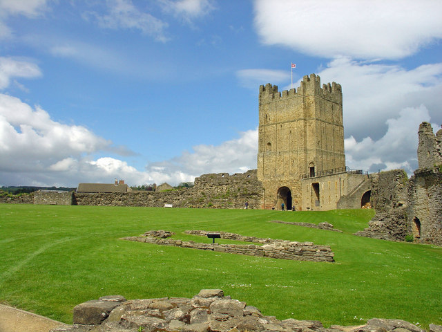
Photo: Robert Scarth from London, England · CC BY-SA 2.0 · Wikimedia Commons
Barnard Castle is a castle in England. Bernard de Balliol built the stone castle in the twelfth century. The free Lokali audio guide runs 6 minutes.
✓ Published October 2026 · how we write these guides
Visitor facts
| Lokali audio guide | 6 min · free |
|---|---|
| Type | Archaeological Site |
| Location | Barnard Castle, United Kingdom |
| Coordinates | 54.5433, -1.9267 |
| Official website | english-heritage.org.uk |
| Languages | 50+, in the Lokali app |
The story
Listen first. Below the walls, out of sight, the River Tees runs fast over rock. On a wet day you hear it before you see it, a steady rush coming up from the gorge. The stone under your hand is cool and rough, a pale sandstone worn smooth at the edges. Wind comes up the valley and moves through the empty windows. This is a ruin, but it is not a quiet one.
You are standing on a cliff edge chosen with great care. The castle sits high above the Tees, at a point where the river once marked a real frontier in northern England. Anyone crossing here could be watched from these walls. The town around you grew up in the castle's shadow and took its name. So the town and the fortress share one name, and one story.
That story begins with a Norman family, the Balliols. After the Norman Conquest, the family received land here from the crown. In the twelfth century, Bernard de Balliol built a castle in stone on this rock. The name you hear today, Barnard, comes from Bernard. Every time someone in the town says where they live, they are still saying the name of a medieval lord.
Here is the first surprise. The Balliol family did not stay only in northern England. One member of the family, John Balliol, became King of Scots in the late thirteenth century. His reign was short and troubled, and it ended badly. But for a few years, a family whose power grew from this cliff above the Tees held the Scottish crown. Few visitors expect that link when they walk through the gate.
As you move through the site, notice how it is divided. The castle is not one building. It is a series of wards, or enclosed courtyards, each one separated by walls and ditches. The inner ward, closest to the cliff, was the safest and most private place. Attackers had to break through one defence after another to reach it. Walk slowly, and you can feel how the ground itself was shaped for war.
Look for the round tower near the cliff edge. It is often called the Balliol Tower, and it is one of the best-preserved parts of the castle. Its curved walls were harder to undermine than square corners. From near the tower, the views open across the gorge and the green slopes beyond. On a clear day, the river shines below between the trees. On a grey day, the mist sits low in the valley.
After the Balliols lost their lands, the castle passed through other powerful hands. In the fifteenth century it came to Richard, Duke of Gloucester — the man who later became King Richard the Third. He planned to spend money on the castle and improve it. His personal badge was a white boar. And here is the second surprise. Look closely in the inner ward, and you can find a boar carved into the stonework near a window.
That small carving is easy to miss. Many people walk straight past it. But it is a direct mark left by one of the most debated kings in English history. Richard's reign lasted only two years, and he died in battle in 1485. His reputation has been argued over ever since. Here, though, he is simply a lord who cared enough about this place to leave his sign on it.
The castle saw serious action again in 1569, during a revolt known as the Rising of the North. Catholic nobles in the north rose against Queen Elizabeth the First. Sir George Bowes held the castle for the queen while rebels laid siege to it. He held out for around eleven days. Then many of his own men slipped over the walls to join the rebels, and he had to surrender.
Even in defeat, that siege mattered. The delay gave the queen's forces valuable time, and the rising soon collapsed. Afterwards, the castle slowly lost its purpose. In the seventeenth century, the estate came to the Vane family, who owned nearby Raby Castle. Much useful stone and timber was taken away from here and used elsewhere. That is one reason the walls you see today are broken and open to the sky.
Ruins have their own kind of afterlife. In the age of Romantic art and poetry, painters and writers came to the north looking for wild scenery. The painter J. M. W. Turner made images of Barnard Castle above the Tees. The novelist and poet Sir Walter Scott set part of his long poem Rokeby in this landscape. For them, a broken castle on a cliff was not a loss. It was a picture.
Today the site is cared for by English Heritage. The open grass, the low walls and the information panels make it easy to read the layout. Take time at the cliff edge and look down to the river and the old stone bridge in the town. If you have time afterwards, walk along the main street. It leads towards the Bowes Museum, a large building in the style of a French château, another surprise in a small English market town.
Before you leave, stand still for a moment in the inner ward. Feel the wind on your face and listen again for the river below. The stone around you was cut and laid by hands more than eight hundred years ago. Kings, rebels and painters all stood near this spot. Now it is your turn. As you walk back through the gate, look up once more at the round tower against the sky.
Key facts
What to look for
Practical tips
Common questions
Is there a free audio guide to Barnard Castle?
Yes — the Lokali app narrates Barnard Castle free of charge in 50+ languages. The guide runs about 6 minutes, covers the history, what to look for on site and practical tips, and works offline once downloaded.
Where is Barnard Castle?
Barnard Castle is in Barnard Castle, United Kingdom, at 54.5433, -1.9267. Tap the map link on this page for directions from where you are.
What is Barnard Castle known for?
Bernard de Balliol built the stone castle in the twelfth century. The town takes its name from Bernard de Balliol.
What should you look for at Barnard Castle?
Richard the Third's boar carved near an inner ward window. The curved walls of the round Balliol Tower. The River Tees running through the gorge below.
What should you know before visiting Barnard Castle?
Walk the wards in order from outer to inner. Bring a windproof layer for the exposed cliff edge.
On the map
Opens directions to Barnard Castle from your location.
More to see near Barnard Castle



Hear Barnard Castle in your language
The full story, narrated, in 50+ languages. Download it before you go and it plays offline, at your own pace, with no ticket and no tour group.