
Photo: Devon Jones · CC BY-SA 3.0 · Wikimedia Commons
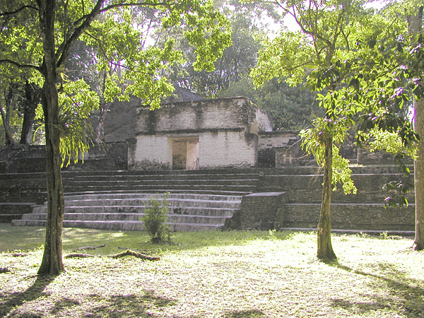
Caracol is a maya city in Belize. Caana remains the tallest building in Belize today. The free Lokali audio guide runs 7 minutes.
✓ Published October 2026 · how we write these guides
Visitor facts
| Lokali audio guide | 7 min · free |
|---|---|
| Type | Archaeological Site |
| Location | Cayo, Belize |
| Coordinates | 16.7639, -89.1176 |
| Official website | caracol.org |
| Languages | 50+, in the Lokali app |
The story
Listen first. Somewhere above you, deep in the canopy, a howler monkey lets out a long, rolling roar. It sounds like wind pushed through a tunnel. The air is heavy and green, and the ground underfoot is soft with fallen leaves. Then the trees open. In front of you, a mountain of pale limestone rises out of the forest, terrace upon terrace, climbing toward the sky. This is Caracol. More than a thousand years ago, this was one of the great cities of the Maya world.
You are standing in the Chiquibul Forest of western Belize, close to the border with Guatemala. Today the site feels remote. The road from San Ignacio is long and rough, and the jungle presses close on every side. But picture it differently. At its height, this was not a lonely ruin in the trees. It was a crowded, working city. Farmland, homes, plazas and roads stretched for kilometres in every direction. The forest you drove through once held thousands of families.
The name Caracol is Spanish. It means snail. It is not what the Maya called this place. The name was given in modern times, after the site came to wider attention in the 1930s. A logger working in the forest reported the ruins in 1937. Stories differ on why the name stuck. Some say it came from the many snail shells found in the soil. Others point to the winding road that coils toward the site. Either way, the label is a modern one, laid over a much older city.
Now turn toward that great stone mountain. This is Caana, a Maya name usually translated as Sky Place. It is not a single pyramid. It is a whole complex stacked on a huge platform. Palaces, courtyards and temples sit on its upper levels. Here is something many visitors do not expect. Caana is still the tallest building in Belize. No modern tower in the country stands higher than this structure of hand-cut stone, raised without metal tools or draught animals.
If you climb Caana, take it slowly. The steps are steep and uneven, and the stone can be slick after rain. Pause on each level and look around. At the top, small rooms open onto inner courtyards. These were probably spaces for the ruling family and the city's elite. Archaeologists found tombs inside this complex. The view from the summit is the real reward. You look out across a sea of trees, and you begin to understand how much of the city still lies beneath them.
Caracol's most famous story is carved in stone. A round altar found at the site, known today as Altar 21, records a war. The inscription describes a victory over Tikal, the powerful city to the northwest in what is now Guatemala. The event dates to the year 562. Before this discovery, many scholars saw Caracol as a minor player. The altar changed that view. A city in these hills had challenged one of the giants of the Maya world, and won.
After that victory, Caracol grew quickly. The seventh century was its golden age. New buildings went up, the population expanded, and the city's influence spread across the region. Meanwhile, Tikal entered a long period with few new monuments. Historians sometimes call it a hiatus. Caracol's rulers recorded their achievements on carved stelae, the tall stone slabs you will see around the plazas. Many are now worn by centuries of rain, but some still carry traces of glyphs, the Maya writing system of pictures and signs.
So how big was this city? For a long time, nobody really knew. The forest hid almost everything. Then, in 2009, researchers flew over the area with lidar. Lidar is a laser system that can map the ground through the tree cover. The results surprised everyone. The scans showed a vast network of terraces, house mounds and roads spread over a huge area. Caracol was far larger than most people had imagined. Estimates suggest that, at its peak, it held well over one hundred thousand people.
Much of what we know comes from decades of patient fieldwork. Archaeologists Arlen and Diane Chase began a long-term project here in 1985. Season after season, they and their teams uncovered buildings, mapped terraces and studied burials. Their work helped show that ordinary families, not only kings, lived well here. Many homes had their own small tombs and fine pottery. The picture that emerged was of a city with a large and fairly prosperous middle layer, not just rulers and farmers.
Look down at the ground as you walk between the plazas. Raised roads, called sacbeob in Mayan, once ran out from the centre like spokes of a wheel. The word means white roads, because they were surfaced with pale plaster. These causeways linked the heart of the city to outer neighbourhoods and markets. Around them, the Maya carved the hillsides into terraces for growing maize, beans and squash. They also built reservoirs to store rainwater through the dry season.
Walk toward the ball court. Here, players once kept a heavy rubber ball in the air, using their hips and bodies rather than their hands. The game was sport, but it also carried deep religious meaning. In the floor of Caracol's courts, archaeologists found round stone markers carved with inscriptions. Altar 21, the stone that told of the war with Tikal, was itself found in a ball court. Stand in the middle and imagine the walls lined with watching crowds.
Like many Maya cities, Caracol eventually emptied. By the end of the ninth and into the tenth century, building had stopped and people moved away. Researchers still debate the reasons. Drought, war, overuse of the land and political breakdown may all have played a part. The forest returned slowly. Roots split the stones. Soil covered the plazas. Today, giant ceiba trees, sacred to the Maya, grow among the ruins. Their pale trunks rise like columns between the temples.
Before you leave, stand still for a moment in the main plaza. Notice the light coming through the leaves, the smell of damp earth and stone. Listen for the birds, perhaps a toucan calling from the canopy. Every mound around you, every lump in the forest floor, may hide a house or a shrine. As you walk back to the road, look at the trees with new eyes. The city of Caracol is still out there, waiting quietly beneath them.
Key facts
What to look for
Practical tips
Common questions
Is there a free audio guide to Caracol?
Yes — the Lokali app narrates Caracol free of charge in 50+ languages. The guide runs about 7 minutes, covers the history, what to look for on site and practical tips, and works offline once downloaded.
Where is Caracol?
Caracol is near Cayo, Belize, at 16.7639, -89.1176. Tap the map link on this page for directions from where you are.
What is Caracol known for?
Caana remains the tallest building in Belize today. Altar 21 records a victory over Tikal in 562.
What should you look for at Caracol?
Worn glyphs still visible on the carved stelae. Round stone markers set into the ball court floor. Small palace rooms around courtyards atop Caana.
What should you know before visiting Caracol?
Leave San Ignacio early; the forest road is slow. Wear shoes with grip for Caana's steep stone steps.
When is the best time to visit Caracol?
Leave San Ignacio early; the forest road is slow.
On the map
Opens directions to Caracol from your location.
More to see in Cayo



Hear Caracol in your language
The full story, narrated, in 50+ languages. Download it before you go and it plays offline, at your own pace, with no ticket and no tour group.