
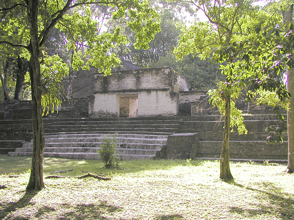
Photo: Denis Barthel · CC BY-SA 4.0 · Wikimedia Commons
Xunantunich is an Ancient Maya archaeological site in western Belize. It is near Cayo, Belize. Xunantunich is a modern name meaning Stone Woman. The free Lokali audio guide runs 7 minutes.
✓ Published October 2026 · how we write these guides
Visitor facts
| Lokali audio guide | 7 min · free |
|---|---|
| Type | Archaeological Site |
| Location | Cayo, Belize |
| Coordinates | 17.0902, -89.1422 |
| Languages | 50+, in the Lokali app |
The story
Listen first. Somewhere in the canopy, a howler monkey lets out a deep, rolling roar, like wind through a tunnel. The grass under your feet is short and springy. The air smells of wet leaves and warm limestone. Above you, a pale stone mountain rises out of the plaza. It is not a hill. It is a building, shaped by human hands well over a thousand years ago. Welcome to Xunantunich, an ancient Maya city on a ridge above the Mopan River.
Your journey here probably began with a small surprise. Most visitors reach the site by crossing the river on a hand-cranked ferry near the village of San Jose Succotz. An operator turns a wheel, and a cable pulls the flat platform across the brown water. It is a slow, quiet crossing. Then the road climbs uphill through forest to the entrance. That short climb matters. The Maya chose this ridge on purpose, and you are about to see why.
First, the name. Xunantunich is not what the city's own people called it. The name is modern, and it comes from Maya words usually translated as Stone Woman or Maiden of the Rock. Locals say a woman dressed in white has been seen on the great pyramid. According to the popular tale, she climbs the stairs and then vanishes into the stone itself. It is a ghost story, not history. But it gave this place the name you see on every sign.
Now look at the tall structure ahead of you. Archaeologists call it El Castillo, which is Spanish for the castle. It stands roughly forty metres high. That makes it one of the tallest ancient buildings in Belize, second only to a great temple at Caracol, further south in this same district. Here is something many visitors miss. El Castillo was not built in a single campaign. Like many Maya pyramids, it grew in layers, with newer construction placed over older phases.
The Maya often built this way. A ruler would cover an earlier temple with a larger one, sealing the old building inside the new. So when you look at El Castillo, you are looking at the outermost skin of a much longer story. Excavations here have found these earlier phases beneath the surface. Think of it less like a single monument and more like a city's memory, stacked upward, generation after generation.
The city reached its peak in the Late Classic period, roughly the seventh to ninth centuries of the common era. During that time the Maya world was a network of rival kingdoms, linked by trade, marriage, and war. Xunantunich sat close to powerful neighbours in what is now Guatemala. Its rise seems tied to those larger political shifts. Then, like many Maya cities in this region, it declined. By around the tenth century, the great plazas were falling quiet.
Walk toward the base of El Castillo and look for the carved band of plaster high on its side. This is the frieze, and it is the second big surprise of the site. It shows sculpted figures and symbols that scholars connect with the sky, the gods, and royal power. Masks, twisted bands, and astronomical signs run across the surface. Look closely. What you see today is a careful replica. The original plaster sits protected underneath, sheltered from rain and sun.
That decision deserves a moment. Maya plaster was made from burned limestone, mixed with water and shaped while soft. In its own time, it was likely painted in strong colours, red especially. Tropical rain is hard on such work. So conservators chose to cover the original and display a faithful copy above it. You are seeing the design as it was meant to be seen, while the real artwork rests safely just behind it.
If you climb El Castillo, take it slowly. The steps are steep and uneven, and the limestone can be slippery after rain. Near the top, the view opens in every direction. Green forest rolls away toward the hills. On a clear day you can look west across the border into Guatemala. This is the reason the Maya built here. From this height, a ruler could see the river, the farmland, and the routes that linked one kingdom to the next.
Back on the ground, notice how the city is arranged. The buildings are set around open plazas, like rooms without roofs. These plazas were where crowds gathered for ceremonies, markets, and public events. Look for the ballcourt, two parallel sloping walls with a narrow alley between them. The Maya ballgame was more than sport. It carried religious meaning, and it was played with a heavy rubber ball that players struck with their hips.
The first recorded excavations here took place in the late nineteenth century. Many decades of work followed, by Belizean and foreign archaeologists alike. Much of what you walk past today was once buried under soil and trees. The forest takes back stone quickly in this climate. Roots split walls. Leaves pile into corners. Every clear plaza you see is the result of steady work to hold the jungle back, and that work continues now.
As you walk, keep your eyes on the trees as well as the ruins. Howler monkeys often move through the canopy at the edges of the site. Large iguanas sometimes sun themselves on warm stone. Bright birds call from the branches. The Maya city was never separate from this living forest. Its people farmed, hunted, and gathered here, and the same river below still gives this valley its green colour.
Before you leave, stand for a moment in the main plaza and look up at El Castillo once more. Notice the way the afternoon light moves across the pale limestone. Listen for the monkeys, the insects, the soft voices of other visitors. People once filled this square for festivals and rituals. Now it holds you, and the quiet. As you walk back down the hill toward the river, look over your shoulder. The stone woman, they say, is still watching.
Key facts
What to look for
Practical tips
Common questions
Is there a free audio guide to Xunantunich?
Yes — the Lokali app narrates Xunantunich free of charge in 50+ languages. The guide runs about 7 minutes, covers the history, what to look for on site and practical tips, and works offline once downloaded.
Where is Xunantunich?
Xunantunich is near Cayo, Belize, at 17.0902, -89.1422. Tap the map link on this page for directions from where you are.
What is Xunantunich known for?
Xunantunich is a modern name meaning Stone Woman. El Castillo rises roughly forty metres above the plaza.
What should you look for at Xunantunich?
Carved plaster frieze high on El Castillo's side. Sloping parallel walls of the ancient ballcourt. Howler monkeys moving through the canopy edges.
What should you know before visiting Xunantunich?
Cross the Mopan River on the hand-cranked ferry. Wear shoes with good grip for the steep steps.
When is the best time to visit Xunantunich?
Climb El Castillo early to avoid midday heat.
On the map
Opens directions to Xunantunich from your location.
More to see in Cayo


Hear Xunantunich in your language
The full story, narrated, in 50+ languages. Download it before you go and it plays offline, at your own pace, with no ticket and no tour group.