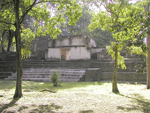
Photo: The original uploader was Aquaimages at English Wikipedia. · CC BY-SA 2.5 · Wikimedia Commons
Cahal Pech is a maya archaeological site in western Belize. It is near San Ignacio, Belize. Name means place of ticks, from modern cattle pasture. The free Lokali audio guide runs 7 minutes.
✓ Published October 2026 · how we write these guides
Visitor facts
| Lokali audio guide | 7 min · free |
|---|---|
| Type | Archaeological Site |
| Location | San Ignacio, Belize |
| Coordinates | 17.1556, -89.0611 |
| Languages | 50+, in the Lokali app |
The story
Feel the limestone underfoot. It is pale, worn smooth in places, and warm by mid-morning. Around you, tall trees lean over grassy courtyards, and the air carries the dry rattle of leaves and the calls of birds you may not recognise. Somewhere below, out of sight, the town of San Ignacio goes about its day. Up here it is quiet. You are standing inside a Maya royal residence on a hilltop, and people lived on this ridge for a very long time.
Start with the name, because it surprises most visitors. Cahal Pech is usually translated from the Maya language as "place of ticks." That is not an ancient royal title. The name is modern. Archaeologists recorded it in the twentieth century, when this hilltop was pasture land and the grass was full of ticks from grazing cattle. Nobody knows for certain what the original inhabitants called their home. The name we use today comes from farmers, not kings.
Now look at where you are. The site sits high above the point where two rivers, the Macal and the Mopan, meet to form the Belize River. Those rivers were roads. Canoes moved goods, food and people through this valley, and a settlement on this ridge could watch the traffic below. Fertile soil along the riverbanks fed the population. A view, water and good farmland — the Maya who settled here chose the spot with care.
Here is the second surprise. Cahal Pech is one of the oldest known Maya settlements in the Belize River Valley. Archaeologists have found evidence of people living on this hilltop roughly three thousand years ago, long before the famous cities of the Maya Classic period reached their peak. The early houses were simple structures of wood and thatch on low platforms. Over many centuries, new buildings rose on top of the old ones, and the hill slowly grew into the stone complex you see now.
That layering is the key to reading this place. The Maya rarely tore down an old building. Instead, they covered it and built a larger one over it, like the layers of an onion. So the walls in front of you are only the final stage. Inside many of these mounds lie earlier floors, earlier staircases and earlier rooms, sealed away. Excavation tunnels have shown archaeologists how the site changed, one generation of builders at a time.
What you see today was not a sprawling city of temples for the public. It was mainly an acropolis — a raised, enclosed complex where an elite family lived, held ceremonies and received visitors. Archaeologists describe it as a palace compound. Picture a powerful household with servants, scribes and craftspeople, living in a cluster of rooms around private courtyards. Ordinary farmers lived in smaller homes scattered across the surrounding countryside.
Walk into the plazas and notice how they connect. The buildings are arranged around open courtyards, some broad and public, some small and tucked away. As you move deeper into the complex, the spaces become tighter and more private. Narrow passages lead from one courtyard to the next. This design controlled who could go where. A guest would pass through the more open areas first. Only trusted people would reach the inner rooms of the ruling family.
Look closely at the stone itself. The builders used local limestone, cut into blocks and set with lime mortar. Originally, many surfaces were covered in smooth plaster and often painted. Today the walls look grey and rough, with dark streaks from rain and patches of moss. Imagine them bright and clean instead, catching the sun on this hilltop. From the valley below, the palace would have looked very different from the ruin you see now.
The tallest temple dominates one side of the main plaza. Its steep steps rise toward a small summit, and its height was a statement of power. Ceremonies on top could be seen by people gathered in the courtyard below. Elsewhere, you can find a ball court — two long parallel structures with a narrow playing alley between them. The Maya ball game was a sport, but it also carried ritual and religious meaning. It was more than entertainment.
The ruins you see were once buried under soil and forest. Systematic excavation and restoration took place mainly in the late twentieth century, led by Belizean archaeologists. Some walls have been consolidated so that visitors can walk safely among them. Other areas remain as grassy mounds, still holding their secrets. As you explore, try to notice the difference between restored stonework and the rougher, untouched sections. Both tell part of the story.
Like many Maya centres, Cahal Pech eventually fell silent. Toward the end of the Classic period, more than a thousand years ago, the population of the site declined and the elite residence was abandoned. Researchers still debate the causes across the Maya region. Drought, warfare, political breakdown and pressure on farmland are all part of the discussion. Here, the forest slowly returned and covered the courtyards, until the hill became pasture in modern times.
Before you climb into the ruins, the small visitor centre near the entrance is worth a few minutes. It displays artefacts and explains the long timeline of the site. Pottery fragments, tools and models help you picture daily life in the palace. Seeing these objects first makes the empty rooms easier to understand. Afterward, the plazas feel less like abandoned stone and more like a home where real people cooked, worked and argued.
One more thing makes this site unusual. Most major Maya ruins sit deep in forest, far from any modern road. Cahal Pech stands right at the edge of a working town. You can walk up the hill from San Ignacio, and on some days you will hear traffic, music or a rooster from nearby houses. Ancient and modern life sit almost side by side. People have lived on and around this ridge for three thousand years, and they still do.
So before you leave, stand in one of the courtyards and turn slowly in a full circle. Look at the steps worn by rain, the roots gripping the edges of old walls, the light moving through the tall trees. Listen for the town below. As you walk back down the hill, notice how the slope rises behind you. That hill is partly natural, and partly the work of many generations of Maya builders.
Key facts
What to look for
Practical tips
Common questions
Is there a free audio guide to Cahal Pech?
Yes — the Lokali app narrates Cahal Pech free of charge in 50+ languages. The guide runs about 7 minutes, covers the history, what to look for on site and practical tips, and works offline once downloaded.
Where is Cahal Pech?
Cahal Pech is near San Ignacio, Belize, at 17.1556, -89.0611. Tap the map link on this page for directions from where you are.
What is Cahal Pech known for?
Name means place of ticks, from modern cattle pasture. Settled roughly three thousand years ago, early Maya village.
What should you look for at Cahal Pech?
Narrow passages linking public plazas to private courtyards. Ball court with two parallel structures and central alley. Steep stairway of the tallest temple above the plaza.
What should you know before visiting Cahal Pech?
Visit the small museum first to understand the timeline. Come early morning before heat builds on the hilltop.
When is the best time to visit Cahal Pech?
Come early morning before heat builds on the hilltop.
On the map
Opens directions to Cahal Pech from your location.
More to see near Cahal Pech


Hear Cahal Pech in your language
The full story, narrated, in 50+ languages. Download it before you go and it plays offline, at your own pace, with no ticket and no tour group.