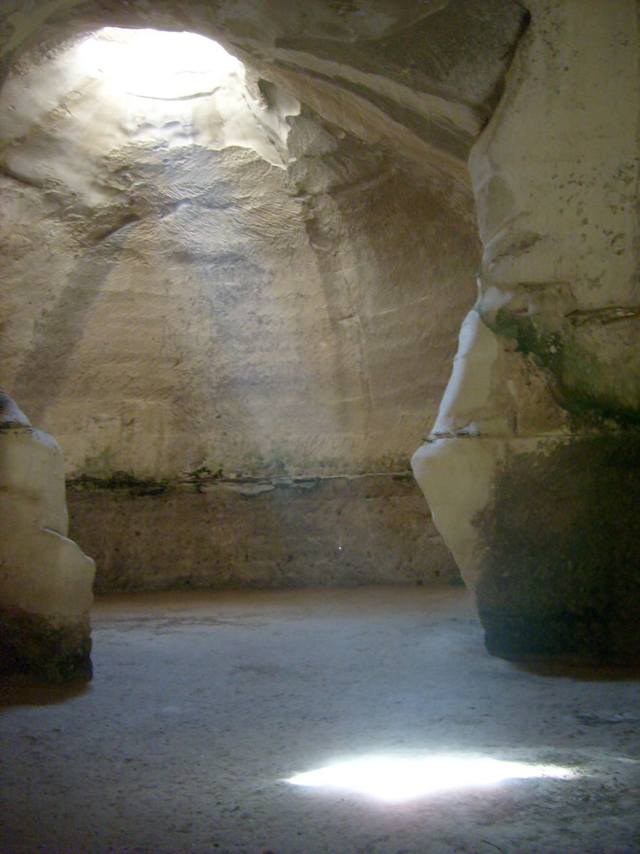
Beit Guvrin-Maresha National Park
31.6131° N · 34.8983° E · National Park
Photo: Chai · CC BY-SA 3.0 · Wikimedia Commons
Beit Guvrin-Maresha National Park is a national park in Israel. UNESCO listed the caves as World Heritage in 2014. The free Lokali audio guide runs 7 minutes.
✓ Published October 2026 · how we write these guides
Visitor facts
| Lokali audio guide | 7 min · free |
|---|---|
| Type | National Park |
| Location | Kiryat Gat, Israel |
| Coordinates | 31.6131, 34.8983 |
| Languages | 50+, in the Lokali app |
The story
Step inside the first cave and the air changes at once. It is cooler here, and slightly damp, with a soft chalky smell like an old classroom. Your footsteps sound muffled. Above you, a single round opening lets in a column of daylight, and the pale walls around it glow almost white. Outside, the hills of the Judean lowlands roll away in shades of green and gold. But the real city here was never only on the surface. Much of it lies underground.
Welcome to Beit Guvrin-Maresha National Park, a short drive east of Kiryat Gat. This is the region Israelis call the Shephelah — the low, rolling foothills between the coastal plain and the Judean mountains. For thousands of years, people lived on these slopes, farmed them, and fought over them. And they did something unusual. They dug down into the rock beneath their feet. Archaeologists have recorded thousands of man-made chambers here, carved over many centuries.
The secret is in the geology. Look closely at the top of any cave entrance. You will see a hard, crusty layer of rock, a little darker than the rest. Locals call it nari. Beneath that thin, tough shell lies soft chalk, which is easy to cut with simple iron tools. The hard crust works like a natural roof. The soft chalk below works like clay waiting to be shaped. This combination is the reason the caves exist at all.
In 2014, UNESCO added these caves to its World Heritage List. The listing describes the site as a small model of a whole land of caves. That idea is worth keeping in mind as you walk. Each cave had a job. Some stored water. Some pressed olives. Some raised birds. Some held the dead. Together they show how an ancient community organised its daily life, in a hidden layer beneath the streets.
Above the caves rises a large mound, called Tel Maresha. A tel is a hill made from layer upon layer of earlier settlements. Maresha appears in the Hebrew Bible as a town in the territory of Judah. The Book of Chronicles names it among the cities that King Rehoboam fortified. But most of what you see today comes from a later period — the Hellenistic era, after Alexander the Great, when Greek culture spread across the eastern Mediterranean.
During those centuries, Maresha was a lively, mixed town. Its people included Idumeans, a local people related to the Edomites of the Bible. There were also Greeks, and a community from the Phoenician city of Sidon, on the coast of modern Lebanon. Here is the first surprise for many visitors. Tombs carved for this Sidonian community still carry painted decorations, with Greek inscriptions naming the people buried inside. This was a town where several languages and faiths met.
Those painted tombs are among the most memorable stops in the park. Along the walls, the artists painted a long line of animals. Some are real, some are imaginary. Among them, guides like to point out a creature with several heads — usually read as Cerberus, the dog that guarded the underworld in Greek myth. The colours have faded over two thousand years, but you can still pick out reds, browns, and the lines of each figure. Take a moment here. These are the faces of a real neighbourhood's beliefs.
Now walk to one of the columbarium caves. The name comes from the Latin word for dove. The walls are covered with rows and rows of small square niches, cut neatly into the chalk. Each niche once held a pigeon or a dove. Scholars still discuss exactly why so many birds were kept here. The likely answers are practical — meat, eggs, and droppings used as fertiliser. Some suggest the birds were also raised for religious offerings. Either way, these rooms once filled with the sound of wings.
The second surprise is about olive oil. Underneath the old town, excavators found many underground olive presses. Look for the heavy stone basins and the slots where wooden beams once pressed the crushed fruit. Working underground made sense. The caves stayed cool and steady in temperature, which helped the oil flow and kept it fresh. Oil was a major product of this region, used for food, lamps, and skin care. Maresha produced far more than its own people could use.
The Hellenistic town did not last. In the late second century BCE, the Hasmonean ruler John Hyrcanus conquered the region and the Idumeans came under Judean rule. Historical sources say the town was later destroyed by the Parthians, a rival empire from the east, in 40 BCE. Maresha never recovered. Life moved to the nearby settlement of Beit Guvrin, in the valley below. Under Roman rule, that town grew into an important city with a new Greek name — Eleutheropolis, which means city of the free.
The Roman city left its own marks. Near the park entrance, you can visit the remains of a Roman amphitheatre, an oval arena where crowds once watched public shows and contests. Its stone seating curves around the open ground. Much later, the Crusaders built a fortress here, and the ruins of a church known as Saint Anne's still stand nearby. Its tall broken apse — the rounded end wall behind the altar — rises from the fields and is easy to spot from the road.
Then come the bell caves, and they are the moment most people remember. These huge chambers were quarried mainly in the early Islamic period, for building stone and lime. Workers cut a small hole through the hard crust, then widened the space as they dug down. The result is a shape like a giant bell, several storeys high. Light falls through the opening at the top and slides down the curved walls. Some caves are connected, so you pass from one great hall to the next. Sound carries beautifully here, and concerts are sometimes held inside.
Before you leave, stand still in one of these bell caves for a minute. Look up at the circle of sky. Look at the walls and you may see faint rows of chisel marks, and occasional crosses or carved symbols left by later visitors and workers. Every scratch belongs to a person who stood where you are standing. As you climb back into the sunlight, notice the quiet fields on the surface. They look simple. Now you know what lies under them.
Key facts
What to look for
Practical tips
Common questions
Is there a free audio guide to Beit Guvrin-Maresha National Park?
Yes — the Lokali app narrates Beit Guvrin-Maresha National Park free of charge in 50+ languages. The guide runs about 7 minutes, covers the history, what to look for on site and practical tips, and works offline once downloaded.
Where is Beit Guvrin-Maresha National Park?
Beit Guvrin-Maresha National Park is near Kiryat Gat, Israel, at 31.6131, 34.8983. Tap the map link on this page for directions from where you are.
What is Beit Guvrin-Maresha National Park known for?
UNESCO listed the caves as World Heritage in 2014. Thousands of man-made chambers are carved into the chalk.
What should you look for at Beit Guvrin-Maresha National Park?
The dark, hard nari crust above each cave entrance. Painted animal frieze inside the Sidonian burial cave. Rows of square dove niches in the columbarium walls.
What should you know before visiting Beit Guvrin-Maresha National Park?
Bring a light layer, since the caves stay cool year-round. Wear shoes with grip for steep steps and dusty floors.
When is the best time to visit Beit Guvrin-Maresha National Park?
Visit the bell caves in late morning for light shafts.
On the map
Opens directions to Beit Guvrin-Maresha National Park from your location.
More to see in Kiryat Gat


Hear Beit Guvrin-Maresha National Park in your language
The full story, narrated, in 50+ languages. Download it before you go and it plays offline, at your own pace, with no ticket and no tour group.