
Old San Juan
18.4661° N · 66.1191° W · Historic District
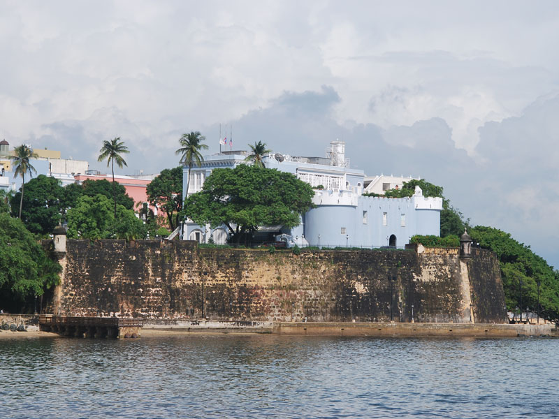
Photo: Picture taken by the U.S. National Park Service. See [www.cr.nps.gov/ worldheritage/fort.h · Public domain · Wikimedia Commons
Old San Juan is a historic district in San Juan, Puerto Rico. Spanish settlers moved here from Caparra in the sixteenth century. The free Lokali audio guide runs 7 minutes.
✓ Published October 2026 · how we write these guides
Visitor facts
| Lokali audio guide | 7 min · free |
|---|---|
| Type | Historic District |
| Location | San Juan, United States |
| Coordinates | 18.4661, -66.1191 |
| Languages | 50+, in the Lokali app |
The story
Start with the ground under your feet. The street here is paved with small, rounded stones in a deep blue-grey colour. They shine after rain and turn almost slate-coloured in the midday sun. Your shoes make a soft, uneven sound on them. Around you, walls painted in yellow, coral, turquoise and pale green rise two and three stories high. Wrought-iron balconies hang above the street. Somewhere nearby, the Atlantic is moving against old stone walls.
This is Old San Juan, the colonial heart of Puerto Rico's capital. It sits on the western tip of a small island, with the open ocean on one side and San Juan Bay on the other. The Spanish chose this spot in the early sixteenth century. Their first settlement on the main island, a place called Caparra, stood inland and was swampy and hard to defend. So the colonists moved here, to a rocky islet that guarded the mouth of one of the best harbours in the Caribbean.
That harbour explains almost everything you will see today. For centuries, Spanish ships passed through the Caribbean on their routes between Europe and the Americas. San Juan was one of the first major ports they reached after crossing the Atlantic. Whoever held this bay held a key to the region. Other European powers understood that too. English and Dutch forces attacked the city more than once, and Spain answered by building some of the largest fortifications in the Americas.
The most famous of these sits at the far western point of the island. Castillo San Felipe del Morro, usually called simply El Morro, rises in layered levels from the sea toward a wide green lawn. Its walls are thick, sloped and built to absorb cannon fire. Work on the fort continued over a very long period, so it grew piece by piece rather than in one single design. Today it is part of the San Juan National Historic Site, managed by the United States National Park Service.
Here is a detail many visitors miss. The great lawn in front of El Morro was once an open field of fire. Defenders kept it clear so that no attacker could approach without being seen. Today that same field belongs to families and kite flyers. On a windy afternoon, the sky above it fills with small coloured shapes pulling against the trade winds. A space designed for war has become one of the most peaceful places in the city.
On the walls of both great forts, and along the city ramparts, look for the small round towers that stick out over the edge. These are garitas, sentry boxes where soldiers stood watch over the sea. Each one has narrow openings and a domed top. The garita has become a national symbol of Puerto Rico. You will see its shape on souvenirs, on logos, and in paintings across the island. It is a simple guard post that now carries the identity of a whole people.
The second great fortress, Castillo San Cristóbal, stands on the eastern side of the old city. While El Morro faced the sea, San Cristóbal was built mainly to protect San Juan from an attack by land. It covers a very large area, with tunnels, ramps and defensive works spread across the hillside. Together, the two forts and the long city wall between them turned this small island into a fortified city. In 1983, UNESCO added the forts and La Fortaleza to the World Heritage List.
Now, about those blue stones beneath you. They are called adoquines. The popular story says they arrived in the holds of Spanish ships as ballast, the heavy weight that kept empty ships stable at sea. Many accounts say they were made from slag, a by-product of iron furnaces, which gives them their unusual colour. Most of the stones you walk on today date from later centuries than the first colonial streets, but the blue colour has become part of the city's character.
Walk down toward the bay and you will reach La Fortaleza. This building began as a fortress, but it was poorly placed for defence and was soon outdone by El Morro. Instead, it became the home of the island's governors. It is often described as one of the oldest executive mansions in the Western Hemisphere that is still in use. That means the person who governs Puerto Rico still lives and works inside walls that colonial governors once used.
Not far away stands the Cathedral of San Juan Bautista, named for Saint John the Baptist. The island itself was first called San Juan Bautista by the Spanish, before the names of the island and the city swapped over time. Inside the cathedral is the tomb of Juan Ponce de León, the Spanish conquistador and the island's first governor. A short walk away, the house known as Casa Blanca was built for his family, although he himself died before he could live there.
At the end of Calle del Cristo, you will find a tiny chapel with a silver-decorated altar. Locals tell a tale about this spot. According to legend, a young rider during a festival race lost control of his horse and went over the edge of the cliff here. Some versions say he survived by a miracle. Others say he did not. Either way, the chapel was built at the point where the street ends, and people still leave small offerings there today.
For a slower moment, head down to the Paseo de la Princesa, a wide promenade that runs along the outside of the city wall beside the bay. Here the wall rises above you, tall and honey-coloured in the late afternoon light. Follow it and you will reach the Puerta de San Juan, an old city gate. In colonial times, important arrivals came ashore near here and walked through this gate into the city. You can still walk through it yourself, uphill toward the cathedral.
Old San Juan is not a museum behind glass. People live here. Laundry hangs from balconies. Music drifts out of open doorways in the evening. Cats sleep in shaded corners, and pigeons gather in the small parks. As you stand here now, notice the colours of the doors, the smell of salt in the air, and the hum of conversation from a café. Then walk on slowly. Every street here ends, sooner or later, at the sea.
Key facts
What to look for
Practical tips
Common questions
Is there a free audio guide to Old San Juan?
Yes — the Lokali app narrates Old San Juan free of charge in 50+ languages. The guide runs about 7 minutes, covers the history, what to look for on site and practical tips, and works offline once downloaded.
Where is Old San Juan?
Old San Juan is in San Juan, United States, at 18.4661, -66.1191. Tap the map link on this page for directions from where you are.
What is Old San Juan known for?
Spanish settlers moved here from Caparra in the sixteenth century. El Morro guards the entrance to San Juan Bay.
What should you look for at Old San Juan?
Domed garita sentry boxes hanging over the fortress walls. Blue-grey adoquines shining on the street after a rain shower. Wrought-iron balconies above brightly painted colonial facades.
What should you know before visiting Old San Juan?
Wear shoes with good grip for the slippery blue cobblestones. Visit El Morro's lawn in late afternoon for kites and cooler air.
When is the best time to visit Old San Juan?
Walk the Paseo de la Princesa near sunset along the city wall.
On the map
Opens directions to Old San Juan from your location.
More to see in San Juan


Hear Old San Juan in your language
The full story, narrated, in 50+ languages. Download it before you go and it plays offline, at your own pace, with no ticket and no tour group.