
Hunza Valley is a high-altitude valley north of Gilgit renowned for terraced orchards, dramatic mountain peaks, and centuries-old fortified settlements. It is in Hunza, Pakistan. Most visitors spend 4–6 hours here. The free Lokali audio guide runs 5 minutes.
✓ Verified August 2026 · how we write these guides
Visitor facts
| Time needed | 4–6 hours |
|---|---|
| Lokali audio guide | 5 min · free |
| Type | Valley |
| Best for | Photography |
| Location | Hunza, Pakistan |
| Coordinates | 36.8447, 74.8844 |
| Languages | 45, in the Lokali app |
The story
The valley opens wide and green between walls of gray rock and white snow. Apricot trees grow in rows along the slopes. A river runs fast and pale at the bottom of the valley. High above, sharp peaks catch the morning light. This is Hunza, in the far north of Pakistan.
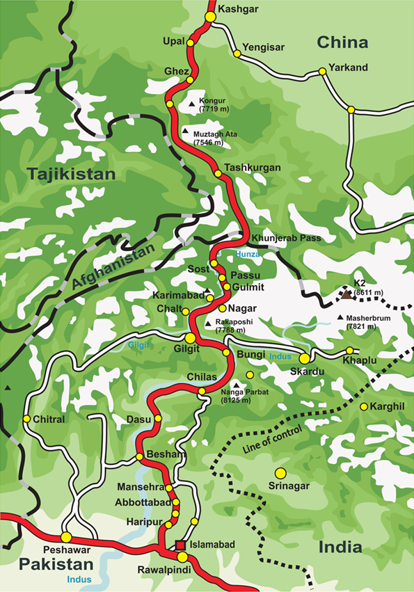
Hunza lies about one hundred kilometers north of the town of Gilgit. The drive takes two to three hours along the Karakoram Highway. This road is one of the highest paved roads in the world. It follows the river through deep gorges and past bare brown cliffs. In places the rock walls climb so high that the sky becomes a narrow strip. The journey itself is a large part of the visit.
For a long time, Hunza was its own small state. Hereditary rulers governed it from their forts. Their title was the Mir. The state kept its own language and its own ways, high and apart from the world below, until it joined Pakistan fully in 1974. The memory of those days still lives in the forts and in the old stories of the valley.
The main town of the valley is Karimabad. It rises in steps up the mountainside. Houses, shops, and small hotels stack along narrow lanes. From its terraces, you look out over the whole valley and the peaks beyond. In spring, the apricot and cherry trees bloom in white and pink. In autumn, the slopes turn gold and red as the leaves change.
Above Karimabad stands Baltit Fort. It is roughly seven hundred years old. For many centuries, the rulers of Hunza lived inside its walls. Over time, the fort fell into decay and was nearly lost. Then careful work brought it back to life. Today it is a museum. You can walk its old wooden rooms, climb its stairs, and look out from its high windows across the valley.
A short way down the valley stands a second fort, called Altit. It is even older than Baltit. Its watchtower is counted among the oldest buildings in the whole region. Altit sits on a rock above the river, with orchards around its base. The careful work to restore it won an international heritage award.
The peaks around Hunza are very high. Rakaposhi rises to seven thousand seven hundred and eighty-eight meters. You can see its broad white face from the valley floor itself, which is rare among great mountains. Nearby stands a thin, sharp peak that people call Lady Finger. Its bare spire of rock points straight up beside the snow of the larger mountains.
Down the valley lies a long lake of strange blue-green water. This is Attabad Lake. It was not always here. In 2010, a great landslide crashed down from the mountainside and blocked the river. The water rose slowly behind the natural dam. It drowned villages and a long stretch of the old road. What remains today is this quiet, deep, and lovely lake. Boats now cross its calm surface.
The people of Hunza are known for their orchards. Apricots grow across the terraces in great number. In summer, families dry the fruit on their flat rooftops, and the roofs turn deep orange in the sun. Cherries, mulberries, apples, and walnuts grow here too. Bread made with local flour and crushed nuts is a part of almost every meal.
There is an old belief that the people of Hunza live very long lives. Travelers have repeated this story for many years. It is hard to prove, and you should hold it lightly. But the food here is simple and fresh, the water comes down from the glaciers, and many people work outdoors well into old age.
For one of the finest views, people climb to a point called Eagle's Nest. It sits high above the valley near the village of Duiker. From there, at sunrise, the first light strikes the peaks one by one. The valley below stays in shadow while the summits turn to gold. It is worth the early start.
Take your time in Hunza. Walk the lanes of Karimabad in the morning. Sit in an orchard and eat fresh fruit straight from the tree. Talk with the people, who are known for their welcome. Watch the light move down the mountains in the evening. The valley rewards those who slow down and stay.
These mountains have framed life in Hunza for thousands of years. Forts have risen and crumbled. Rulers have come and gone. The river still runs, the orchards still bloom, and the high white peaks still stand watch over it all. You leave with the quiet of the valley held inside you.
Key facts
What to look for
Practical tips
Common questions
How long do you need at Hunza Valley?
Plan 4–6 hours. That is the time most visitors spend at Hunza Valley. The free Lokali audio guide adds about 5 minutes of narration you can listen to as you walk, so it fits inside your visit rather than adding to it.
Is there a free audio guide to Hunza Valley?
Yes — the Lokali app narrates Hunza Valley free of charge in 50+ languages. It covers the history, what to look for on site and practical tips, and it works offline once downloaded.
Where is Hunza Valley?
Hunza Valley is in Hunza, Pakistan, at 36.8447, 74.8844. Tap the map link on this page for directions from where you are.
What should you know before visiting Hunza Valley?
Drive the Karakoram Highway in daylight for views.
What is Hunza Valley known for?
About 100 kilometers north of Gilgit by road.
What is the best time to visit Hunza Valley?
Visit in spring for apricot blossoms or autumn for harvest.
On the map
Opens directions to Hunza Valley from your location.
More to see in Hunza



Hear Hunza Valley in your language
The full story, narrated, in 50+ languages. Download it before you go and it plays offline, at your own pace, with no ticket and no tour group.