
Khunjerab Pass is a mountain pass in Hunza, Pakistan. At 4,693 metres, one of the world's highest paved border crossings, linking Pakistan to China. Most visitors spend 10–12 hours here. The free Lokali audio guide runs 5 minutes.
✓ Verified August 2026 · how we write these guides
Visitor facts
| Time needed | 10–12 hours |
|---|---|
| Lokali audio guide | 5 min · free |
| Type | Mountain Pass |
| Best for | Photography |
| Location | Hunza, Pakistan |
| Coordinates | 36.8639, 75.4169 |
| Languages | 45, in the Lokali app |
The story
The air is thin here, and you feel it in your chest with every step. You are standing higher than almost any road can take you. Bare ridges roll away on every side, dusted with snow even in summer. A cold wind never quite stops. This is Khunjerab Pass, the rooftop of the long road between Pakistan and China.
The drive to the top is long and slow. The road climbs in tight bends, gaining height with every turn. Your ears pop. The villages thin out and then stop. Grass gives way to bare stone. By the time you reach the gate, the world below feels very far away, and the quiet is almost complete.
The pass sits at about four thousand seven hundred meters above the sea. That is high enough to leave you light-headed and short of breath. There are no trees. There is little but rock, grass, snow, and sky. This is the highest paved border crossing anywhere in the world, the place where one country ends and another begins.
A marked gate stands at the very top. On one side lies Pakistan. On the other lies China, and the wide region of Xinjiang beyond. Travelers stop here to stand with one foot in each country. The border is drawn along the spine of the mountains, where the land itself decides which water flows to which side.
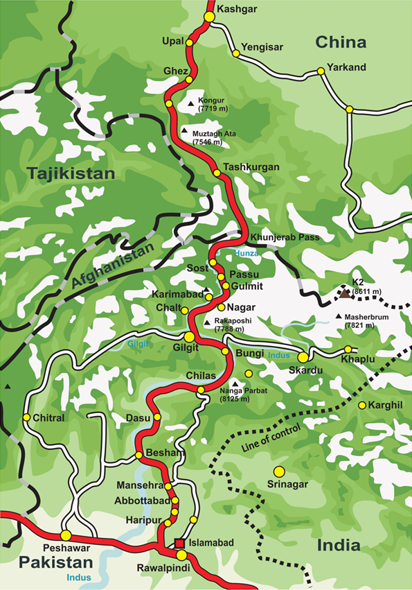
This high point is the crown of a famous road. The road is the Karakoram Highway. It links the north of Pakistan with western China, climbing through some of the steepest country on earth. Khunjerab is its highest point. Everything on the long drive up has been leading you here, to this windy saddle in the sky.
Building the road was hard and costly. Workers from both countries cut it through the mountains over many years. It was finished in 1979 and opened to travelers in 1986. Hundreds of workers died in the effort, lost to rockfall and accident. Markers and small memorials along the route remember some of those who were lost. Every traveler who crosses here moves along a path paid for in lives.
The name Khunjerab carries a dark old meaning. In the local tongue, people say it can be read as a valley of blood. The story goes that long ago, raiders waited in these heights to rob those who passed. Whether the tale is true or not, it fits the place. This was never an easy crossing.
Around you spreads a protected wild land. It is called Khunjerab National Park. The park was set up to guard the rare animals that live at this height. Few people see them, but they are there. The land is harsh, yet life has learned to hold on in the cold and the thin air.
Watch the slopes and you may be lucky. Wild ibex pick their way across the rocks. High above, the great Marco Polo sheep carry their long curling horns. Marmots whistle from the grass and dart into their burrows as you pass. Somewhere among the ridges moves the snow leopard, pale and almost never seen. These animals are rare, and the park exists so they may continue.
The weather here changes fast and without warning. Sun can turn to snow within an hour, even in the warm months. The pass is usually closed in winter, buried under deep drifts. For only part of the year is the gate open at all. You have come during a narrow window when the road is clear.
Take a slow breath and notice your body. Your heart beats faster. A headache may press at your temples. This is the thin air doing its work. Stay calm, move gently, and drink water. Do not run or climb here; even a few quick steps can leave you breathless. The height that makes this place feel unreal is the same height your body is working hard to manage.
Look back down the way you came. The road falls away in long curves toward the green valleys far below. From up here, the whole journey makes sense. People have always wanted to cross these mountains, to trade and to meet, and this cold gate is where they finally break through to the other side.
Stand quietly for a moment at the top of the world. The wind pulls at your coat. The border sign creaks. Two great countries meet at this lonely line of stone and snow. Then you turn back toward the warmth and the lower air, carrying the strange, light feeling of having stood on the very edge.
Key facts
What to look for
Practical tips
Common questions
How long do you need at Khunjerab Pass?
Plan 10–12 hours. That is the time most visitors spend at Khunjerab Pass. The free Lokali audio guide adds about 5 minutes of narration you can listen to as you walk, so it fits inside your visit rather than adding to it.
Is there a free audio guide to Khunjerab Pass?
Yes — the Lokali app narrates Khunjerab Pass free of charge in 50+ languages. It covers the history, what to look for on site and practical tips, and it works offline once downloaded.
Where is Khunjerab Pass?
Khunjerab Pass is in Hunza, Pakistan, at 36.8639, 75.4169. Tap the map link on this page for directions from where you are.
What should you know before visiting Khunjerab Pass?
Acclimatize at lower altitude before coming up here.
What is Khunjerab Pass known for?
Sits at roughly 4,700 meters above sea level.
What is the best time to visit Khunjerab Pass?
The journey from Gilgit takes a full day.
On the map
Opens directions to Khunjerab Pass from your location.
Reference
More to see in Hunza


Hear Khunjerab Pass in your language
The full story, narrated, in 50+ languages. Download it before you go and it plays offline, at your own pace, with no ticket and no tour group.