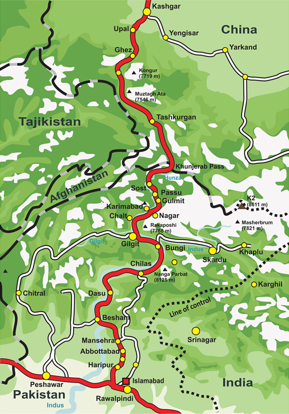
Karakoram Highway is a road in Hunza, Pakistan. One of the world's highest paved roads, connecting Gilgit to the Chinese border at Khunjerab Pass. Most visitors spend 6–8 hours here. The free Lokali audio guide runs 5 minutes.
✓ Verified August 2026 · how we write these guides
Visitor facts
| Time needed | 6–8 hours |
|---|---|
| Lokali audio guide | 5 min · free |
| Type | Road |
| Best for | Photography |
| Location | Hunza, Pakistan |
| Coordinates | 36.7184, 74.3149 |
| Languages | 45, in the Lokali app |
The story
The road bends ahead of you. On one side, a cliff rises straight up toward the sky. On the other, the land falls away to a river far below. Snow peaks fill the distance, pale against the blue. The engine strains on the climb. You are on the Karakoram Highway, one of the highest paved roads in the world.
The highway runs through Gilgit and the valleys around it. It connects Pakistan with China across the mountains. The road climbs from the plains of Pakistan, threads through deep gorges, and rises to the border at the Khunjerab Pass. From there it crosses into China and joins the road network on the far side.
This road was a huge task to build. Pakistan and China built it together, working from both ends. The work went on for about two decades in very hard terrain. The road was completed in 1979 and later opened more widely in the 1980s. Many workers from both countries lost their lives during the construction, and they are remembered along the route.
The road follows old paths. For centuries, traders moved through these valleys on foot and with pack animals. They carried silk, salt, and other goods between South Asia, Central Asia, and China. The highway follows parts of these ancient trade routes, which some people call branches of the Silk Road. You travel in the tracks of those early caravans.
For much of its length, the road runs beside rivers. Near Gilgit, it follows the Indus, and then the Hunza river further north. The water is grey with fine silt carried down from the glaciers above. The road clings to the valley wall, cut into the bare rock high above the stream, with the slope dropping sharply away.
The mountains here are among the tallest on Earth. The Karakoram range holds many high peaks and some of the longest glaciers outside the polar regions. From points along the road, you can see giant walls of snow and broad fields of ice. The scale is hard to take in from a moving vehicle, so it is worth stopping to look.
The land along the road is restless. Rock falls and landslides are common here. Melting snow, heavy rain, and earthquakes loosen the steep slopes. Work crews are often out clearing and repairing the road. In some years, a large landslide has blocked the route completely, and one such slide even formed a lake across the valley.
There are good places to stop along the way. Marked viewpoints look out over the rivers and the peaks. Small towns and roadside stalls offer food, tea, and a chance to rest. Near Gilgit, a well-known point marks the meeting of three great mountain ranges. Signs and rest stops help travelers break the long journey into stages.
The weather shapes every trip on this road. The high passes can close with snow during the cold months of the year. Even in summer, the weather can change fast at altitude, from clear sky to cloud and rain. Check the road conditions before you set out. Local drivers and hotel staff usually know what the road is doing that day.
Travel on this road takes time. The distances look short on a map, but the going is slow. Tight curves, steep climbs, and rough patches keep speeds low for hour after hour. Plan for more time than you expect, and do not rush. On the Karakoram Highway, the journey itself is the point, not the speed of it.
If you can, travel during the day. The views are the main reason to come, and you will want to see them clearly. Daylight is also far safer on a mountain road with sharp drops. Stop often, get out of the vehicle, and stand at the edge of a viewpoint to feel the true size of the land around you.
Come prepared for the heights. Carry water and warm clothing, even in summer, because the air is thin and cool at the high points. Keep some food with you, as towns can be far apart. If you feel the effects of the altitude, rest and drink water, and do not climb higher until you feel better.
Stand still beside the road for a moment. Feel the cold wind coming off the ice. Watch the river run far below, the same way it has run for ages. People cut this road through some of the hardest country on Earth, by hand and by sheer will. On the Karakoram Highway, you travel a path that joins distant lands, high among the great mountains.
Key facts
What to look for
Practical tips
Common questions
How long do you need at Karakoram Highway?
Plan 6–8 hours. That is the time most visitors spend at Karakoram Highway. The free Lokali audio guide adds about 5 minutes of narration you can listen to as you walk, so it fits inside your visit rather than adding to it.
Is there a free audio guide to Karakoram Highway?
Yes — the Lokali app narrates Karakoram Highway free of charge in 50+ languages. It covers the history, what to look for on site and practical tips, and it works offline once downloaded.
Where is Karakoram Highway?
Karakoram Highway is in Hunza, Pakistan, at 36.7184, 74.3149. Tap the map link on this page for directions from where you are.
What should you know before visiting Karakoram Highway?
Travel by day for safety and for the views.
What is Karakoram Highway known for?
Connects Pakistan to China over the Khunjerab Pass.
What is the best time to visit Karakoram Highway?
The drive from Gilgit to Hunza takes roughly 3 hours.
On the map
Opens directions to Karakoram Highway from your location.
More to see in Hunza


Hear Karakoram Highway in your language
The full story, narrated, in 50+ languages. Download it before you go and it plays offline, at your own pace, with no ticket and no tour group.