Dardanos
40.0758° N · 26.3628° E · Archaeological Site
Photo: Wikimedia Commons contributor · CC BY-SA 3.0 · Wikimedia Commons
Dardanos is a city in Greek mythology. It is in Canakkale, Türkiye. The Dardanelles strait takes its name from Dardanos. The free Lokali audio guide runs 6 minutes.
✓ Published October 2026 · how we write these guides
Visitor facts
| Lokali audio guide | 6 min · free |
|---|---|
| Type | Archaeological Site |
| Location | Canakkale, Türkiye |
| Coordinates | 40.0758, 26.3628 |
| Languages | 50+, in the Lokali app |
The story
Listen first. Out on the water, a cargo ship moves slowly through the strait, and its engine hum carries across to the shore. The wind here almost never stops. It comes down the Dardanelles from the north, smells of salt and pine resin, and pulls at your clothes. Under your feet the ground is dry, stony and uneven. This low headland, a short drive south of Çanakkale, is the place called Dardanos.
The name may sound familiar, and there is a good reason. The narrow channel in front of you, the Dardanelles, takes its name from this place. Long before the strait had a modern name, sailors and writers connected this stretch of water with the ancient city of Dardanos. So, in a quiet way, you are standing at the source of a word that appears on maps all over the world.
The story behind the name begins with myth. In ancient Greek tradition, Dardanus was a son of Zeus, the king of the gods. Legend has it that Dardanus came to this region and founded a people, the Dardanians. In Homer's poems about the Trojan War, the Dardanians fight on the side of Troy. Trojans are even called Dardanians at times. Remember, this is legend and poetry, not documented history — but it shaped how the ancient world saw this coast.
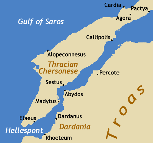
The real city of Dardanos was a Greek settlement on the Asian shore of the strait. It stood between two better-known neighbours. To the north was Abydos, at one of the narrowest points of the channel. To the south lay the plain of Troy. Dardanos was never a great power. It was a modest coastal town, and like many such towns, it lived by watching the ships that passed its harbour.
Here is the first surprise. This small town once hosted a meeting that changed the history of the Mediterranean. In 85 BCE, the Roman general Sulla met King Mithridates the Sixth of Pontus here. Pontus was a powerful kingdom on the Black Sea coast. The two men agreed the Peace of Dardanos, which ended a long war between Rome and that kingdom. Ancient historians describe the meeting, and it is one of the best-recorded moments in the town's life.
Think about why they chose this place. Dardanos sat on the line between two worlds. Behind it lay Asia, where Mithridates had his support. Across the water lay Europe and the road toward Rome. A treaty signed on this shore had a clear message — this was the border, and both sides could reach it. Even today, standing here, you can see both continents in a single view.
So what survives of the ancient city? Honestly, not much that a casual visitor will notice. There are no tall columns or complete temples here. Much of the site is low ground, scrub, and scattered stone. Archaeologists have studied burial mounds in the area, called tumuli. A tumulus is an artificial hill of earth raised over a grave. These finds show that people of some wealth were buried near the town in ancient times.
Now turn your attention to the later layer of this headland. Many centuries after the Greeks, the Ottoman Empire defended the strait with forts and gun positions along both shores. On this coast stands the Dardanos Battery, known in Turkish as Dardanos Tabyası. A battery is a fortified position for heavy guns. Its earth walls and gun platforms still shape the ground, and they are much easier to see than the ancient ruins.
This is the second surprise for many visitors. In 1915, during the First World War, British and French warships tried to force their way through the Dardanelles toward Istanbul. The guns along this shore fired at the fleet, and the ships fired back. The Dardanos Battery was one of the positions that came under heavy fire. On 18 March 1915, the Allied naval attack failed, and several warships were lost in the strait.
Because of that history, Dardanos is a place of memory for many people in Türkiye. Groups of students and families come here to see the old gun positions and the memorial on the site. You may hear teachers telling the story to schoolchildren. The tone is quiet and respectful. This is not a battlefield of mass graves like the Gallipoli peninsula across the water, but the soldiers who served here are remembered with care.
Take a moment to look across the strait. The European shore is close, and on a clear day you can pick out hills, villages and roads. The water between the shores looks calm, but the current here is strong. It flows steadily from the Sea of Marmara toward the Aegean. Sailors have always respected it. That current is one reason why every power in history wanted to control this coast.
The light here changes the place through the day. In the morning, the sun rises behind you, and the European shore glows in soft gold. By late afternoon, the light comes low across the water and turns the strait silver. Ships become dark shapes against the brightness. If you visit near sunset, the old earthworks throw long shadows, and their outline becomes much easier to read.
Before you leave, stand still for one more minute. Notice the layers around you. There is the myth of a son of Zeus, the small Greek town, the Roman peace treaty, and the Ottoman guns of 1915. All of them belong to this one low headland. Listen again to the ship engines and the wind. The strait is still busy, still watched, still carrying the name of the city that once stood exactly here.
Key facts
What to look for
Practical tips
Common questions
Is there a free audio guide to Dardanos?
Yes — the Lokali app narrates Dardanos free of charge in 50+ languages. The guide runs about 6 minutes, covers the history, what to look for on site and practical tips, and works offline once downloaded.
Where is Dardanos?
Dardanos is in Canakkale, Türkiye, at 40.0758, 26.3628. Tap the map link on this page for directions from where you are.
What is Dardanos known for?
The Dardanelles strait takes its name from Dardanos. Sulla and Mithridates agreed peace here in 85 BCE.
What should you look for at Dardanos?
Grassed earth walls marking the old Ottoman gun positions. The European shore of the strait clearly visible opposite. Large cargo ships moving slowly through the narrow channel.
What should you know before visiting Dardanos?
Wear sturdy shoes for the dry, stony, uneven ground. Bring a windproof layer; the strait wind rarely stops.
When is the best time to visit Dardanos?
Come in late afternoon when low light shows the earthworks.
On the map
Opens directions to Dardanos from your location.
More to see in Canakkale


Hear Dardanos in your language
The full story, narrated, in 50+ languages. Download it before you go and it plays offline, at your own pace, with no ticket and no tour group.